THE FAULT
Queen Charlotte’s fault, named after its located near Queen Charlotte’s Islands in Canada, is a transform fault of approximately 700 km long (see figure 1). A transform fault is a horizontal motion that occurs when two plates are forced to move along each other (see figure 2). Here, the Pacific plate and the North America plate are moving along each other. The Pacific plate is moving upwards in the northwest direction, while the North America plate is moving downwards. (Fossen, 151) This type of fault is usually connected on both ends to other faults, ridges or to subduction zones. A subduction zone occurs at plate margins, when the plates converge and one of the plates is plunging under the other one. (Mackie, Abstract) In this case, Queen Charlotte’s fault carries the strain to the Cascadia subduction zone below it and the Alaska subduction zone above it. Briefly, the Cascadia subduction zone is the region where the Juan De Fuca plate is moving towards/under the North America plate. Also, the Queen Charlotte-Fairweather fault system is the region known as the junction of Queen Charlotte’s Fault and the Fairweather fault along the Alaskan coast. (Earthquake) The Queen Charlotte fault system has been active since the Triassic period to today.
Queen Charlotte’s fault, named after its located near Queen Charlotte’s Islands in Canada, is a transform fault of approximately 700 km long (see figure 1). A transform fault is a horizontal motion that occurs when two plates are forced to move along each other (see figure 2). Here, the Pacific plate and the North America plate are moving along each other. The Pacific plate is moving upwards in the northwest direction, while the North America plate is moving downwards. (Fossen, 151) This type of fault is usually connected on both ends to other faults, ridges or to subduction zones. A subduction zone occurs at plate margins, when the plates converge and one of the plates is plunging under the other one. (Mackie, Abstract) In this case, Queen Charlotte’s fault carries the strain to the Cascadia subduction zone below it and the Alaska subduction zone above it. Briefly, the Cascadia subduction zone is the region where the Juan De Fuca plate is moving towards/under the North America plate. Also, the Queen Charlotte-Fairweather fault system is the region known as the junction of Queen Charlotte’s Fault and the Fairweather fault along the Alaskan coast. (Earthquake) The Queen Charlotte fault system has been active since the Triassic period to today.
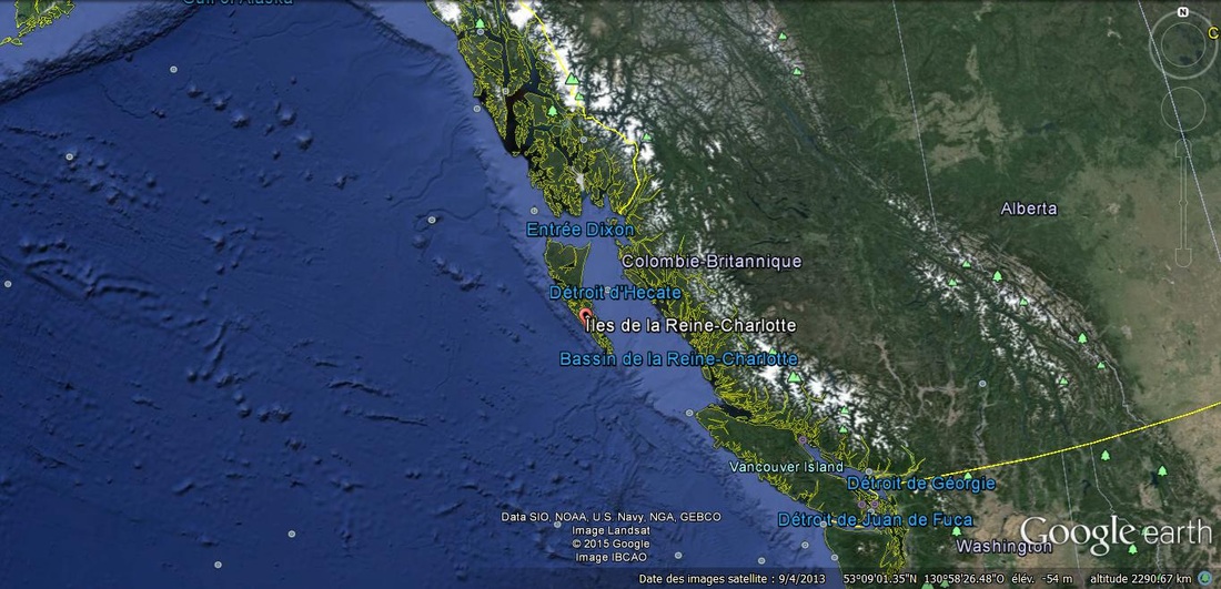
Figure 1: Queen Charlotte's fault as seen from space. Picture provided by Google Earth application.
On figure 1, we can see the west coast of Canada, the boundary with the United States of America and a small portion of Alaska. As explained before, Queen Charlotte's fault is located between the Alaska subduction zone, which is illustrated by the dark contour on the northest of the continent, and the Cascadia subduction zone, which starts near Vancouver island.
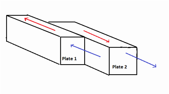
Figure 2: Strike-slip fault. In this case, Plate 1 illustrates a motion similiar to that of the Pacific plate, and Plate 2 illustrates that of the North America plate. The red arrows illustrate the resulting plates movement. The blue arrows illustrate the acting force.
Since Queen Charlotte’s fault is located on the oceanic floor, all the observations mainly consist of submarine topography, record and analysis of seismic activity and its connection to the surrounding geological formations. (Brown Bulletin 54, 153) For instance, Canada’s largest earthquake occurred the 22nd of August 1945, an earthquake of magnitude 8.1 occurred near Prince Rupert city; its study revealed a lot about the nearby fault. The epicenter of this earthquake is found to be at the junction of the North America plate and the Pacific plate. The study of this earthquake also confirmed that “although the Queen Charlotte’s fault is dominantly a right-lateral transform […] fault, there is also compression between the Pacific and North American plates along the southern portion of the fault where [the two plates converge with the Juan de Fuca plate]”. (Magnitude, 2) The seismologists found this earthquake to be a result of a combination of reverse and strike-slip faulting: which chategorizes this fault as an oblique transform fault (see figure 3). Reserve faulting is often the result of a compression force between the two plates; the hanging wall block moves upwards while the footwall block moves downwards (see Firgure 4). (Fossen, 151) The combination of both faulting types results in an oblique motion towards the northwest.
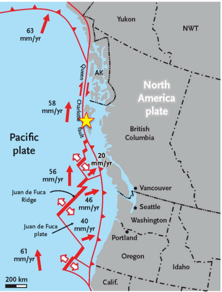
Figure 3: Thie figure illustrates the relative motion of the Pacific plate, the North America plate and Juan de Fuca plate. The yellow start is the epicenter of the largest earthquake that occured in Canada (22nd August, 1945). The tick marks (triangular) point in the direction of the dip of the fault. In reverse faulting, the dip direction is towards the hanging wall - in this case the North America plate. (Clague)
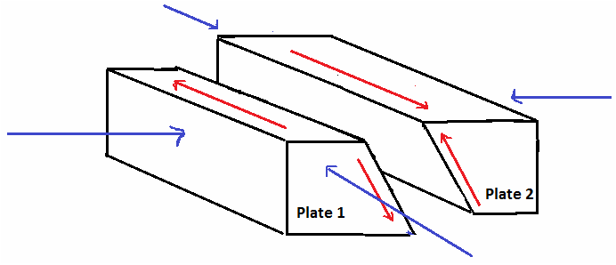
Figure 4: Combination of reverse and strike-slip faulting. The blue arrows illustrate the acting forces and the red arrows illustrate the resulting motion. Plate 1 illustrates a motion similar to that of the Pacific plate, Plate 2 illustrates that of the North America plate.
SECONDARY FEATURE
Secondary features can also be observed on Queen Charlotte’s fault. According to A.Sutherland Brown’s article Geology of the Queen Charlotte Islands, folds with low intensity are observable near the junction of the Pacific and North America plates. A few folds on the sea floor are observable on the photo provided by Google Earth. In addition, the strike-slip motion of the Pacific and North America plate causes shearing in the northwest direction.
The folds in volcanic rocks are mainly monoclinical and dip less than 30 degrees. In Brown’s article, they are compared to “wraped panels of volcanic rock”. However, the folds observed on sedimentary rocks near the fault zone are overturned folds and steeper. It is observed that the folds in Triassic and Jurassic rocks are oriented west and northwest. These oldest folds have wavelengths of 10-16 miles with amplitudes of 2-3 miles (see figure 5). The folds observed in Cretaceous rocks are slightly overturned with their axial plane trace perpendicular to the Rennell fault system also oriented northwest (see figure 6,7). Then, in the Ternary rocks, the dip of the folds is increasing towards the Queen Charlotte basin, which Brown attributes to compaction forces. (Brown Bulletin 54, 156)The folds observed in all these rocks are all gentle (interlimb angle of 120-180 degrees). (Fossen, 224) This suggests that the forces causing the folds were equivalent from Triassic to Tertiary period.
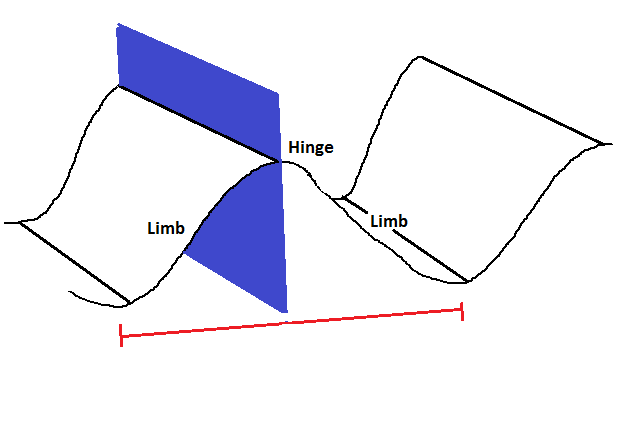
Figure 5: This illustration represents a fold. The Hinge point being at the top of the anticline. The Limbs are the sides the anticline/syncline. The blue plane illustrates the axial plane. The red line represents a wavelength.
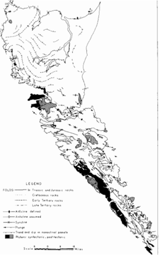
Figure 6: Fold systems along rocks from the Triassic, Jurassic, Cretaceous and Tertiaty periods. This illustrations displays the folds observed in different aged rocks, the observable aticlines and synclines and the plunge and trend of the folds, on a scale of 14 miles. (Brown Bulletin 54, 157)
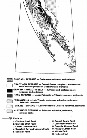
Figure 7: Fault system near Queen Charlotte's Islands. The age of the rocks are illustrated and the formations that occured on this area are also displayed. (Dehler, 3)
By studying the position of the folds with respect to the main fault line, the folds seem to be caused by regional stress in addition to the conjugate fault system. In other words, the folds appear to be controlled by the northwest strike-slip fault and by the compression of the Pacific and North America plates. In addition, the relationship between Queen Charlotte’s fault and the system of faults around it could explain the shearing in the northwest direction. (Brown Bulletin 54, 156)
THE GEOLOGY
A geological map of the southern Queen Charlotte’s islands from a study by Sutherlands A. Brown and W.J Jeffery in 1958-59 displays the location and age of the observed rocks, the beddings, foliation, fold axes, faults, contact and contour interval of 1000ft (see figure 8). The Preliminary Geological map locates the rock from the Jurassic period and the plutonic rocks found on the islands.
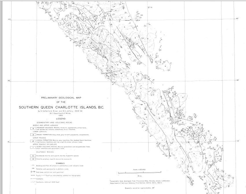
Figure 8: This is the Preliminary Geological Map made by Sutherland Brown and W.D. Jeffery in 1958-59. (Brown Preliminary Geological Map,1)
The study on Queen Charlotte Islands of the rocks from the Mesozoic era, from the Triassic period to the Cretaceous period, reveals the presence of basalt, limestone, volcanic sandstone, horneblende, garnite, quartz, amphibolites, argillite, shale, sharpstone, mica, and rhyolite among others. (Brown Bulletin 54, 38) Among a variety of sedimentary and plutonic rocks, an important amount of volcanic rocks is mostly found in the southern islands. The beddings vary from a layer of volcanic rocks to a layer of sedimentary rocks, followed by an unconformity, a layer of sedimentary rocks, and a younger layer of volcanic rocks. Overall, the study leads to the conclusion that the fault occurs in sedimentary and volcanic rocks, since they are the most common rocks on the islands. (Brown Preliminary Geological Map, 1)
An interesting note is the diversity of elements found on Queen Charlotte’s islands. A study on the sedimentary basins located offshore of British Columbia was performed at the University of Victoria which evaluated the evolution of the proportions of hydrocarbon formation in the basins (see figure 9). This research agrees with the affluence in elements of Canada’s west coast and concluded that the conditions and locations are possible for gas and oil formation. (Sedimentary)
An interesting note is the diversity of elements found on Queen Charlotte’s islands. A study on the sedimentary basins located offshore of British Columbia was performed at the University of Victoria which evaluated the evolution of the proportions of hydrocarbon formation in the basins (see figure 9). This research agrees with the affluence in elements of Canada’s west coast and concluded that the conditions and locations are possible for gas and oil formation. (Sedimentary)
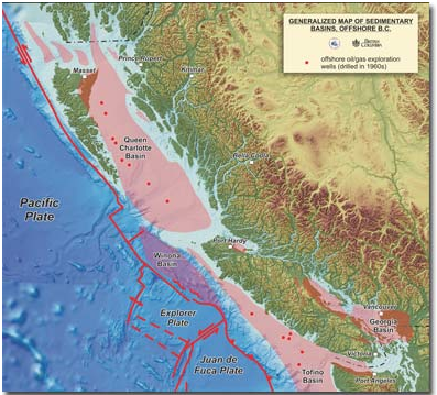
Figure 9: This illustration reveals the location of the different basins on the west coast of Canada, near Queen Charlotte's fault, that have the necessary conditions for gas and oil formation. (Sedimentary)
The Queen Charlotte's fault is often compared to the San Andreas fault. While the San Andreas fault is continental fault, both display similar faulting system.
REFERENCES
Brown, Sutherland A. "Chapter Four: Structural Geology." Bulletin 54: Geology of the Queen Charlotte Islands British Columbia. British Columbia, n.d. Web. 22 May 2015. <http://www.empr.gov.bc.ca/Mining/Geoscience/PublicationsCatalogue/BulletinInformation/BulletinsAfter1940/Pages/Bulletin54.aspx>.
"Magnitude 7.7 Queen Charlotte Islands Region." Iris Teachable Moments(2012): 1+. Iris. 2012. Web. 22 Mar. 2015. <http://www.iris.edu/hq/files/programs/education_and_outreach/retm/tm_121028_queencharlotte/121028queencharlotte.pdf>.
"Earthquake Map of Vancouver Island." Mid Island News. WordPress, n.d. Web. 22 Mar. 2015. <http://midislandnews.com/vancouver-island-marine-communication/earthquake-map-of-vancouver-island>.
Brown, Sutherlands A., and W.J Jeffery. Preliminary Geological Map - Southern Queen Charlotte's Islands. Rep. Victoria, B.C: British Columbia Departement of Mines, 1960. Print.
"Sedimentary Basins, Offshore B.C." University of Victoria. University of Victoria, n.d. Web. 27 Mar. 2015. <http://communications.uvic.ca/releases/release.php?display=photos&id=610>.
Mackie, David. Subduction beneath the Queen Charlotte Islands? : The Results of a Seismic Refraction Survey. Rep. Geophysics ed. N.p.: U of British Columbiia, 1985. Print. Plate Tectonics - British Columbia - Queen Charlotte Islands.
Clague, J. J. At Risk: Earthquakes and Tsunamis on the West Coast. Vancouver: Tricouni, 2006. Print.
Dehler, Sonya A. A Seismic Refraction Study of the Queen Charlotte Fault Zone. Rep. Geophysics ed. N.p.: U of British Columbiia, 1986. Print.
Fossen, Haakon. Structural Geology. Cambridge: Cambridge UP, 2010. Print.
 RSS Feed
