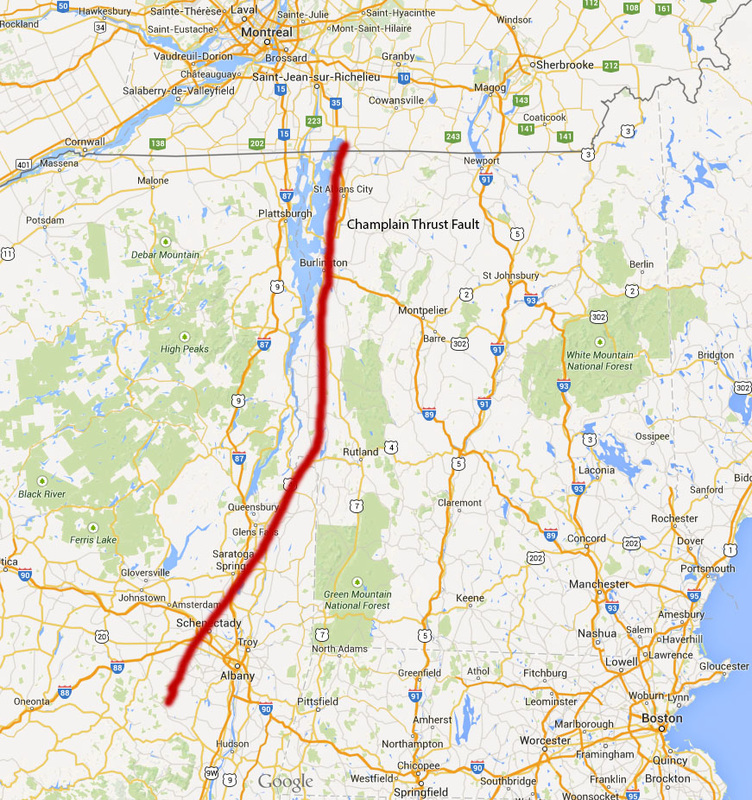
 Fig. 1 - Approximate fault trace of the Champlain Thrust Fault, running from near the Canadian border to the Catskill Plateau (VGS 2003) |
| Vermont is best known for its bucolic countryside, cows, hippies and Champ, the friendly monster of massive Lake Champlain. While most visitors to the Green Mountain State pass their time skiing or eating Ben and Jerry’s, geologists flock to an outcrop on the shores of Lake Champlain, near Burlington. Lone Rock Point offers the best glimpse of the Champlain Thrust – an approximately 200 mile thrust fault that was active around 450 million years ago (Vermont Geological Survey, 1998). Thrusts are low angle faults where the hanging wall is displaced over the footwall, created under contractional tectonic regimes (Fossen, 2010). In the case of the Champlain Thrust, compressional stress was the result of the Taconic Orogeny, a mountain-building process that formed the Green Mountains from 500-400 million years ago. Skiers can thank the Taconic Orogeny event for Jay Peak, Mount Mansfield, Mont Ellen and Killington Peak, among many others. As the North American continent was subducted under the oceanic crust (as the ancient Iapetus Ocean closed), an accretionary prism formed. Thrust faults developed in this accretionary prism (Fig. 2) due to the high compressive stress, most prominently the Champlain Thrust (Stanley 1987). | 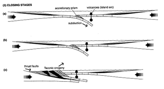 Fig. 2 - Diagram of stress that caused the Taconic Orogeny (from Johnson, 1998) CLICK ON IMAGE FOR CLOSER VIEW 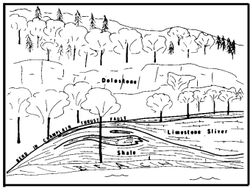 Fig. 3 Sketch of the Champlain Thrust near Lone Rock Point (Stanley 1987) |
The east-dipping thrust has shoved older Cambrian rock over younger Ordovician rock to the west (see geologic map - Fig. 2). The phenomenon of older rock overlying younger rock is clearly visible at Lone Rock Point (Fig. 3). The carbonate Cambrian rock (hanging wall) is Dunham Dolostone, visible at many outcrops in the Champlain Valley. The less resistant Ordovician rock (footwall) is a dark gray shale known as the Iberville formation, and also includes flysch and melange. The unconformity between the Ordovician shale and the Cambrian dolostone is striking because the shale has been deformed much more than the more resistant dolostone (University of Vermont, 2010). The exposed fault zone is notably planar and continuous (Stanley, 1987).
The throw of the fault at Lone Rock Point is estimated at 8,850 feet (Vermont Geological Survey, 1998). Moving north from Lone Rock Point, the throw decreases as the fault moves up towards Canada (Stanley 1987). Displacement is taken up by other thrust faults near Philipsburg, Qc., eventually becoming Logan’s Line (which separates the folded Appalachian rocks from the flat Paleozoic sedimentary beds of the St. Lawrence Valley). These other thrust faults are part of the so-called Taconic thrust belt (see Fig. 4). The Champlain Thrust is considered to be the frontal and basal fault of this forward-propogating system of ancient thrusts (Hayman and Kidd, 2002). The throw of the Champlain fault decreases south of Lone Rock Point as well, estimated at 6,000 feet just south of Burlington, tailing off to the south (Stanley, 1987). The trace of the Champlain Thrust is relatively straight and easy to follow north of Burlington. It strikes to the north and dips at approximately 15° to the east (Stanley, 1987). Moving south from Burlington, however, the trace becomes increasingly obscured by higher angle faults that have formed more recently than the original thrust, as evidenced in the geologic map (Fig. 2).
Displacement along the thrust was originally estimated at 9 miles (Doll et al. 1961). Stanley (1987) bumped up the estimate to 35-50 miles, while Rowley (1982) proposed displacement of 65 miles using a new method based on study of sedimentary sequences across Atlantic-type margin continental shelves.
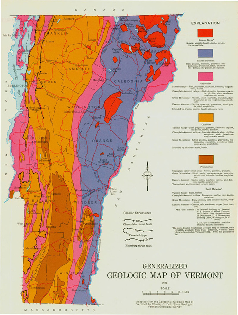
Fig. 4 - Geologic map of Vermont (VGS, 1970) Red-Igneous Rocks; Blue-Silurian-Devonian; Pink-Ordovician (i.e. Iberville Shale, "footwall" of thrust fault); Yellow-Cambrian (i.e. Durham Dolostone, "hanging wall" of thrust fault); Orange-Precambrian
Geologists have long been puzzled over certain structures and stratigraphic profiles associated with the Champlain Thrust, and more generally the Taconic Thrust Belt. West-central Vermont is not exactly Structural Geologist Heaven - there is not an abundance of outcrops and it is often hard to differentiate sedimentary facies. Hayman and Kidd (2002) proposed that there has been reactivation of pre-thrusting, flexure-induced normal faults, as well as one post-thrust normal fault (the Mettawee fault) that obscures the original thrust map pattern. The Mettawee fault reduces the map width of the Champlain Fault and decreases the apparent differences in structural level between the Champlain fault and nearby thrust fault systems. The exact age of the Mettawee fault is unknown, although it is believed to have formed some time after the Champlain Thrust but still during the Taconic orogeny event (Hayman and Kidd, 2002).
The Champlain Thrust is a visible reminder of the ancient orogeny that created the Green Mountains. The next time I find myself in Burlington, VT, I think I will make a pilgrimage to Lone Rock Point to admire the dolostone and shale, run my hand along an ancient fault and maybe catch a glimpse of Champ.
The Champlain Thrust is a visible reminder of the ancient orogeny that created the Green Mountains. The next time I find myself in Burlington, VT, I think I will make a pilgrimage to Lone Rock Point to admire the dolostone and shale, run my hand along an ancient fault and maybe catch a glimpse of Champ.
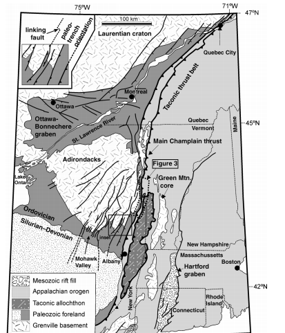
Fig. 4 - Geologic provinces of New England (Hayman and Kidd 2002). All faults are normal except for the Champlain Thrust and the rest of the Taconic thrust belt (including Quebec's Logan Line) CLICK ON IMAGE FOR CLOSER VIEW
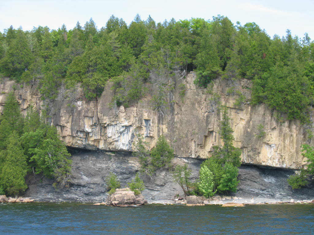
Fig. 5 - Champlain Thrust at Lone Rock Point in Burlington, Vermont, looking east from Lake Champlain. Older Dolostone overlies younger Shale. Photo taken on June 13, 2004. © 2004 Stephen S. Howe. From the Vermont Geological Society
References
Doll, C.G., Cady, W.M., Thompson, J.B. and Billings, M.P. (1961). Centennial geologic map of Vermont Montpelier, Vermont Geologic Survey, scale 1:250,000.
Fossen, H. (2010). Structural Geology. Cambridge: Cambridge University Press.
Gale M. (1998). “Geology of Vermont: Champlain Thrust Fault at Lone Rock Point, Burlington VT”. Vermont Geological Survey. Accessed March 17, 2015. http://www.anr.state.vt.us/DEC/geo/chthrust.htm
Hayman, N. W., & Kidd, W. S. F. (January 01, 2002). Reactivation of prethrusting, synconvergence normal faults as ramps within the Ordovician Champlain-Taconic thrust system. Geological Society of America Bulletin, 114, 476-489.
Johnson, C.W. 1998. The Nature of Vermont: Introduction and Guide to a New England Environment. UPNE, 2nd Edition. ISBN: 0874518563
Rowley, D. B. (August 01, 1982). “New methods for estimating displacements of thrust faults affecting Atlantic-type shelf sequences: With an application to the Champlain Thrust, Vermont.” Tectonics, 1, 4, 369-388.
Stanley, R.S., 1987, “The Champlain thrust fault, Lone Rock Point, Burlington, Vermont”. Geological Society of America Centennial Field Guide - Northeastern Section.
University of Vermont. “Geologic History of the Champlain Valley” UVM.edu. Accessed March 17, 2015. http://www.uvm.edu/shelburnelandscape/nature/geology.html
 RSS Feed
