By Matthias Balk-Forcione
General Description
The Rio Grande Rift is a north-trending continental rift that formed when the Earth’s crust began to thin and stretch in a west/east direction about 36 million years ago (2). The rift spans from Northern Mexico to Colorado, where most of it resides in New Mexico. The rift contains the Rio Grande, the 5th longest river in North America and the 20th longest river in the World (6). Most rifts form in the oceans where plates are diverging so the Rio Grande Rift is unique in being one of the few active continental rifts on the planet. There is a great debate as to whether the rift formed through active rifting from the up-welling of the asthenosphere into the crust or passive rifting from the extensional stresses at the plate boundaries which led to magma upwelling (2). Regardless, the rift continues to actively rift today. The rift is associated with multiple interconnected basins which are filled with thick layering of sediments, such as sandstone, siltstone and conglomerate that are generally referred to as the Santa Fe group (2). These sediments date as far back to the late Oligocene to the early Miocene, shortly after the rift opened (5). Though there many small basins, the northern section of the Rio Grande Rift is characterized by the three largest basins; The San Luis Basin, the Española, and most importantly the Albuquerque Basin (or the Middle Rio Grande Basin) which are visible in the first figure. Out of the three, the Albuquerque Basin is the largest of the basins and even one of the largest along the Rio Grande Rift (8).
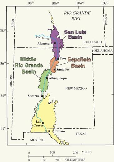 Figure 2: A simple map showing where the three main northern basins are situated. |
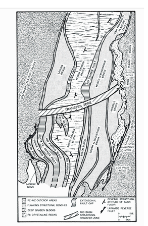 Figure 3: Geological/Structural Framework of the The Albuquerque Basin
 Detailed Description
Focusing on the Albuquerque Basin, the basin ranges from 80 to 240 km in length and 5 to 95 km in width. The sediments that fill this basin, also known as the Santa Fe group, can reach depths of 6 km (1). From the geological map, the Albuquerque Basin is separated by the North and the South Graben Blocks which are down-dropped along extensive low angle faults. Both Grabens have opposite dips where the North due to both having different controlling faults acting on them: The North Graben is controlled by the west-dipping Rio-Grande fault and the South Graben is controlled by the east dipping Santa Fe-Coyote fault (3). The grabens are classified as asymmetrical ‘half-grabens’: a graben that is bordered by one fault rather than two parallel faults on each side. The Rio Grande fault, the dominating structural component of the North Graben, has a fault throw of about 4.5 to 6 km and within the basin range has high angle faults dipping around 60˚ and low angle faults dipping to about 17˚. On the other hand, the South Graben being controlled by the Santa Fe fault, has a throw of 10 km and faults dipping from 65˚ to 15˚ in the South Graben (1 & 3).
Focusing on the Albuquerque Basin, the basin ranges from 80 to 240 km in length and 5 to 95 km in width. The sediments that fill this basin, also known as the Santa Fe group, can reach depths of 6 km (1). From the geological map, the Albuquerque Basin is separated by the North and the South Graben Blocks which are down-dropped along extensive low angle faults. Both Grabens have opposite dips where the North due to both having different controlling faults acting on them: The North Graben is controlled by the west-dipping Rio-Grande fault and the South Graben is controlled by the east dipping Santa Fe-Coyote fault (3). The grabens are classified as asymmetrical ‘half-grabens’: a graben that is bordered by one fault rather than two parallel faults on each side. The Rio Grande fault, the dominating structural component of the North Graben, has a fault throw of about 4.5 to 6 km and within the basin range has high angle faults dipping around 60˚ and low angle faults dipping to about 17˚. On the other hand, the South Graben being controlled by the Santa Fe fault, has a throw of 10 km and faults dipping from 65˚ to 15˚ in the South Graben (1 & 3).
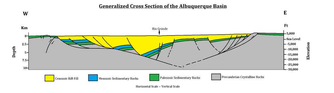
Figure 4: A drawing of a cross section of the Albuquerque Basin showing the dates of rocks within the basin as well as geological features/structures such as half grabens and low angle faults
Along the basin are many dormant volcanoes are riddled along the length of the rift. The Albuquerque volcanoes, also known as the Three Sisters, are three unique volcanic features visible on the landscape which are special due to being aligned from early fissure eruptions (7). Another notable volcanic feature is the Valles Caldera for being one of the largest and youngest calderas on the planet. The caldera, shown in Figure 6, collapsed around 1.2 million years ago during what is considered a super volcano eruption similar to scale of Yellowstone’s previous eruptions (4).
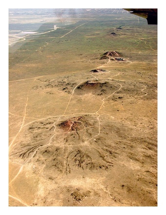 Figure 5: The Three Sisters (Volcanoes) | 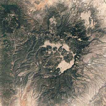 Figure 6: Satellite image of the Valles Caldera |
| Deformation As stated before, the debate as to whether the rift began actively where the intrusion/up-welling of magma into the crust which thinned it or passively from extensional forces from the moving plates which led to magma up-welling (2). Regardless, The rift opened in multiple phases: the first was approximately 36-27 (again, debated) million years ago when the crust began to spread apart which generated shallow basins with many low angle normal faults (1). This spreading of the crust also allowed hot magma from the mantle to rise up which created many volcanoes, mineral deposits and hot springs (2). The eruptions that occurred were rhyolitic and basaltic in nature (3). Starting around 20-15 million years ago, the Farralon Plate subducted underneath the North American Plate, which inturned created a transform boundary between the Pacific Plate and the North American Plate. Due to the transofrm plate boundary, the Southwestern U.S. went under extensional stress and a major fault formed, known as the San Andreas Fault. The fault began to drift northward, due to the pulling of the Pacific Plate and continues to move northward today (3). This extensional stress caused the rift to open up larger basins in the northern and central parts of the rift, such as the Albuquerque basin. As these basins formed, the crust became thinner and dropped down to form what are called grabens, or half-grabens to be more exact (1). This process still occurs with an estimated rift movement of approximately 2 mm per year (4). Figure 7 shows this by measuring the average movement a year using GPS signals situated throughout the rift. Volcanism was still very prevalent during this time but had now become more basaltic due the oceanic Farallon plate subducting under the North American Plate contaminating the up-welling magma (3). | 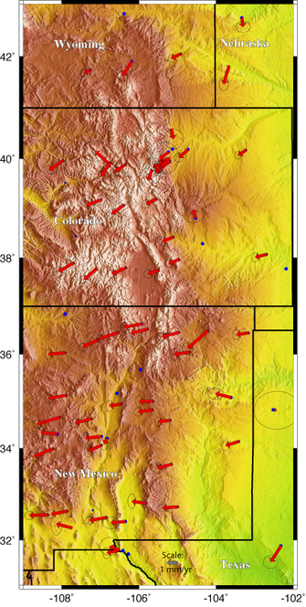 Figure 7: The red arrows signify the motion of GPS sites used to measure the extension of the rift. |
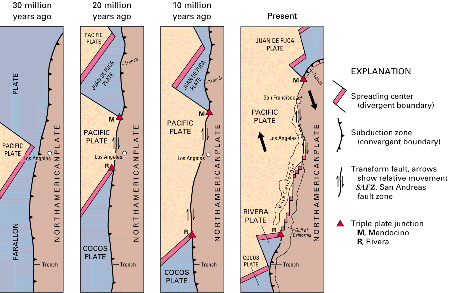
Figure 8: Illustration of the Farralon Plate subducting and the birth of the San Andreas Fault
References
(1)Keller, G. Randy, and Steven M Cather. Tectonic Setting of the Axial Basins of the Northern and Central Rio Grande Rift. Basins Of The Rio Grande Rift. Boulder, Colo.: Geological Society of America Vol 291, (1994) 6-15. Web.:
http://books.google.ca/books?id=ybECAQAAQBAJ&printsec=frontcover&source=gbs_ge_summary_r&cad=0#v=onepage&q&f=false
(2)Kelley, Shari. 'Conceptual Models Of The Rio Grande Rift'. Lite Geology 31 (2012): 2-4. Web.: http://geoinfo.nmt.edu/publications/periodicals/litegeology/31/lite_geo_31spring12.pdf
(3)Pinet, Bertrand, and C Bois. The Potential Of Deep Seismic Profiling For Hydrocarbon Exploration. Paris: Éditions Technip Vol. 41, (1990) 275-205 1990. Web.:
http://books.google.ca/books?id=fMcsCLBTXH4C&printsec=frontcover&source=gbs_ge_summary_r&cad=0#v=onepage&q&f=false
(4)Aconcagua.geol.usu.edu,. 'Rio Grande Rift FAQ'. N.p., 2015. Web.: http://aconcagua.geol.usu.edu/~arlowry/RGR/faq.html
(5)Veatch, Steven. 'Colorado Earth Science: THE RIO GRANDE RIFT'. Coloradoearthscience.blogspot.ca. N.p., 2012. Web.: http://coloradoearthscience.blogspot.ca/2012/12/the-rio-grande-rift.html
(6)Encyclopedia Britannica,. 'Rio Grande | River, United States-Mexico'. N.p., 2014. Web.:
http://www.britannica.com/EBchecked/topic/504243/Rio-Grande
(7)Nps.gov,. 'The Volcanoes - Petroglyph National Monument (U.S. National Park Service)'. N.p., 2015. Web.:
http://www.nps.gov/petr/planyourvisit/volcanoes.htm
(8) Aubele, Jayne. "Geologic History of the Rio Grande Rift" The Bosque Education Guide, (E.N.M.R.D.), Web.:
http://www.emnrd.state.nm.us/SPD/documents/GeologicStory.pdf
 RSS Feed
