Not an illustration of seafloor spreading
- M. Liu
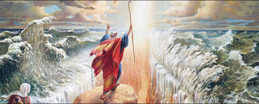
Where Moses’ famed parting of the Red Sea most obviously differs with the geological parting of the Red Sea lies in orientation. In the biblical account Moses parted it widthwise from coast to coast, whereas contemporary continental drift parts it lengthwise straight down the middle.
One can convincingly argue that ever since biblical times, the Red Sea has played an important role in human civilization. Today, the Suez Canal linking the Mediterranean to the Gulf of Suez makes the Red Sea a crucially important junction for trade between Europe and Asia. As such, over the millennia it has seen plenty of contest, war, and exchanges of power along its banks. However, one thing has remained constant - for the past few million years, the Red Sea has slowly and quietly gotten wider. In this post, we shall seek to explain concisely the reasons behind this width gain.
One can convincingly argue that ever since biblical times, the Red Sea has played an important role in human civilization. Today, the Suez Canal linking the Mediterranean to the Gulf of Suez makes the Red Sea a crucially important junction for trade between Europe and Asia. As such, over the millennia it has seen plenty of contest, war, and exchanges of power along its banks. However, one thing has remained constant - for the past few million years, the Red Sea has slowly and quietly gotten wider. In this post, we shall seek to explain concisely the reasons behind this width gain.
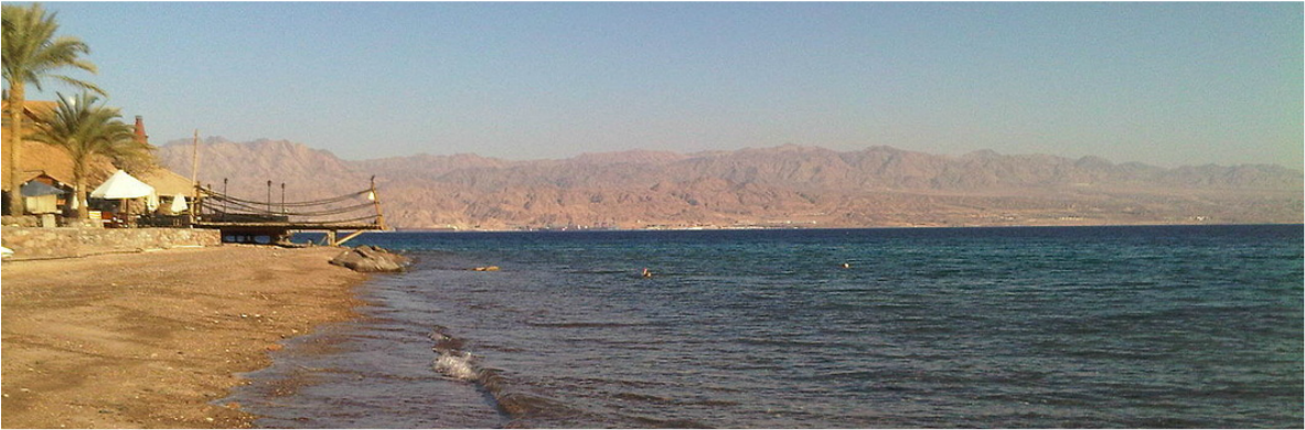
The Red Sea coastline. Note the jagged hills.
| Roughly the size of California, the Red Sea is a 2000km long and 370km wide body of water located between Africa and the Arabian Peninsula (6). The sea is generally shallow, with an average depth of <500m. However, along the rift in its center, depths can reach more than 2km (4). At the northern tip, the Red Sea branches into the Gulf of Suez and the Gulf of Aqaba. At southern end, it is connected to the Gulf of Aden through a narrow chokepoint called the Bab el Mandeb (‘Gateway of Sorrows’). From our geological map, we see that the coasts of the red sea are Precambrian in age. By the seafloor spreading mechanism, the oceanic crust next to the rift is the youngest, gradually increasing in age as we move to either coast. The Red Sea Rift is formed by the spreading between the Arabian Plate and the African plate, which is hypothesized to have begun roughly 30 million years ago. Most of the spreading occurred in the past 4 million years (3). |
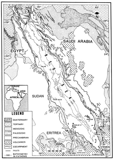 Age of surrounding terrain and depth contours | We note the correspondence between the two shorelines in our geological map. It is easy to visualize the two coasts fitting back together. From the depth contours, we see that the sea is deepest along the middle of the rift. It is not difficult to trace the ridge axis right down the middle of the sea. This coincides with the divergent boundary between the Arabian and African plates in the map below. From the contours, we see that the sea floor is the deepest in the center and gradually shallows out towards the tips. This observation is consistent with our displacement ellipse models. We see that the age of both coasts (ignoring quaternary coastal deposits) are Precambrian, and this also agrees with the hypothesis that the two coasts were once connected. 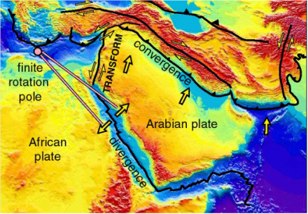 Plate boundaries, movement, type, and elevation. Red is highest - purple is lowest. The above map makes clear the relative movement of the plates in our region of interest. The divergent boundary between the African Plate and the Arabian plate lies right under the Red Sea. This boundary is also called the Red Sea Rift and is an younger parallel of the larger, older mid ocean ridges such as those under the Atlantic and the Pacific (1). It is the stress caused by the movement of these plates away from each other over the past few million years that eventually resulted in the modern Red Sea. This movement is continuing, and we will seek to explain concisely the mechanism behind this below. |
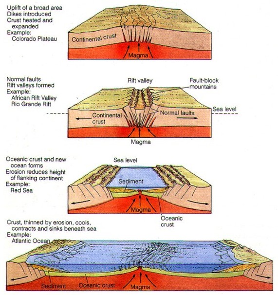
An Illustration of Seafloor Spreading. The Red Sea is currently at stage 3.
A divergent continental boundary between the previously attached Arabian and African plates is responsible for the creation of the Red Sea. We summarize the concepts illustrated above. A hot mantle plumes lifts up the continental crust, causing the crust to stretch, fracture, and eventually form a rift valley (note the formation of normal faults). As the crust slides atop of the mantle away from the elevated magma plume, a rift valley is formed (5). Eventually the crust stretches thin enough to be below sea level and an infantile sea, such as the Red Sea, is born. As the plates are pulled apart, new oceanic crust is formed when magma rises up through the rift. As expected, we see volcanic activity in the Red Sea Rift - the most recent submarine eruption having occurred in 2007 (1, 2). Hot brine and metalliferous mud on the sea floor are further evidence supporting the presence of magma beneath the rift. As slab pull continues to pull the coasts apart, in a few million years, we might expect a renaming of the Red Sea to the Red Ocean.
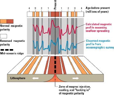
We know that the Red Sea is young from observing its outwardly visible geological features, but there is another, less obvious method to quantitatively determine its age.
We know that the Red Sea is young from observing its outwardly visible geological features, but there is another, less obvious method to quantitatively determine its age.
 What it looks like in theory | 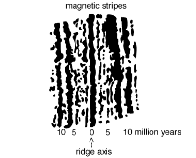 What it looks like in practice |
As a stretch of new oceanic crust is formed from magma along a mid ocean ridge, iron in the hot magma orients itself with the earth’s magnetic field and this magnetization becomes permanent once the magma cools (5). Well known to geologists, the Earth’s magnetic poles are not fixed and over the past 5 million years, have swapped positions around 20 times. The ages of these paleo-poles are well documented. Thus, by measuring how magnetization reverses along bands of oceanic crust can we not only date these bands, but by measuring each band’s width and the corresponding time period of the paleo-pole, we can also calculate the rate of sea floor spreading (3). For the Red Sea, this rate has been determined to be around 1cm/yr on average over the last 4 million years. For reference, the Mid Atlantic Ridge spreads at a much faster 2.5 cm/yr.
****Sea floor spreading w/bill nye the science guy****
Warning: Clip ends in a cliffhanger
Sources (all primary)
1 - Butler, Rob. "The Dead Sea Transform in Lebanon." The Dead Sea Transform in Lebanon. Leeds University, n.d. Web. 30 Mar. 2015. <http://www.see.leeds.ac.uk/structure/leb/index.htm>.
2 - Eva, Hartai. "Geology." N.p., n.d. Web. 25 Mar. 2015. <http%3A%2F%2Fmeip.x5.hu%2Ffiles%2F1529>.
3 - Freund, Raphael, Israel Zak, and Zwi Garfunkel. "Age and Rate of the Sinistral Movement along the Dead Sea Rift." Nature.com. Nature Publishing Group, n.d. Web. 30 Mar. 2015.
<http://www.nature.com/nature/journal/v220/n5164/abs/220253a0.html>.
4 - JOKELA, ARTHUR W. "SUBMARINE GEOLOGY OF THE RED SEA." (1965): n. pag. MIT. Web. 25 Mar. 2015. <http://dspace.mit.edu/bitstream/handle/1721.1/59607/26057777.pdf>.
5 - Larh, John C. "Sea-Floor Spreading and Subduction Model." Sea-Floor Spreading and Subduction Model. USGS, n.d. Web. 30 Mar. 2015. <http://pubs.usgs.gov/of/1999/ofr-99-0132/>.
6 - Lindquist, Sandra J. "The Red Sea Basin Province: Sudr-Nubia(!) and Maqna(!) Petroleum Systems." (n.d.): n. pag. USGS. Web. 25 Mar. 2015. <http://pubs.usgs.gov/of/1999/ofr-99-0050/OF99-50A/OF99-50A.pdf>.
 RSS Feed
