| The San Rafael Swell lies in Emery County and northern Wayne County in central Utah (Figure 1 shows the exact delimitations of the San Rafael Swell) (Gilluly 1928, Freeman et al. 2008). It is a broad, asymmetrical, anticline stretching about 50 km long and 120 km wide (Jeffrey et al. 2011). The major axis of the anticline, from south to north, first trends north-northeast. Then, it abruptly turns east-northeast in the central part of the swell, and then north-northeast again. The San Rafael Swell has elevations ranging from 4000 to 7000 feet above sea level. Beds over the eastern edge of the swell have elevations ranging from 4000 to 6000 feet above sea level and dip steeply eastward. These beds are dominated by a monoclinal fold with a central limb dipping eastward as well (Freeman et al. 2008, Johnson & Johnson 2000). Beds over the center and on the west edge of the uplift dip gently westward with a dip angle of two to five degrees west, and have elevations ranging from 6000 to 7000 feet above sea level (Freeman et al. 2008, Hawley et al. 1968). See Figure 2 for a picture of a portion of the San Rafael Swell. |
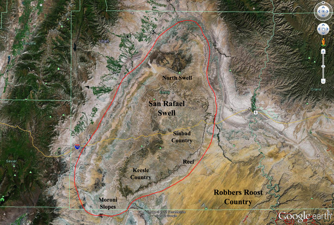
Figure 1. San Rafael Swell Specific Delimitations http://files.geology.utah.gov/maps/geomap/30x60/pdf/ofr-404.pdf
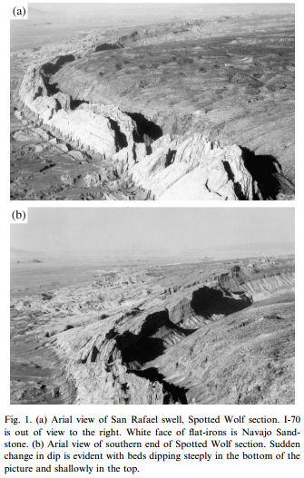
Figure 2. Portion of San Rafael Swell, "The Reef" Section (Johnson & Johnson 2000)
Differential erosion from resistance in different sedimentary rocks has carved the San Rafael Swell into a distinctive topography (Gilluly 1928). Exposed sedimentary rocks from the uplift range in age from the Carboniferous to Jurassic periods (Bartsch-Winkler et al. 1990). The inner part of the San Rafael Swell, called Sinbad Country, is underlain mainly by rocks of Permian and Triassic age. This section is of low relief. The outer part of the swell is a steep ridge, called the Reef. It is formed mainly of resistant sandstone of the Glen Canyon Group of Triassic and Jurassic age. The Carmel Formation of Middle and Late Jurassic age and younger strata are exposed outside the Reef, while the oldest rocks exposed in the San Rafael Swell crop out in the deep canyons of Straight Wash and the San Rafael River; they are probably of Early Permian and Pennsylvanian age (Hawley et al. 1968). The central limb is characterized morphologically by Navajo Sandstone (Johnson & Johnson 2000). This can be seen in the following geologic map and profiles (Figure 3 and Figure 4).
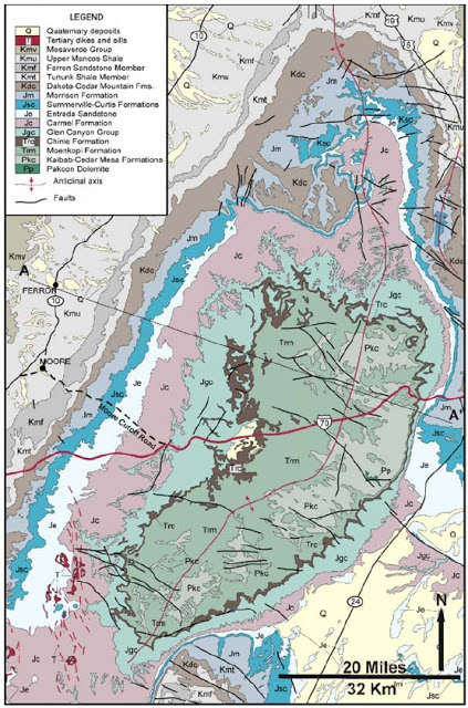
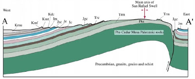
Figure 3. Geologic Map and Cross-Section of San Rafael Swell http://written-in-stone-seen-through-my-lens.blogspot.ca/2011/08/flight-plan-part-i-geology-of-san.html
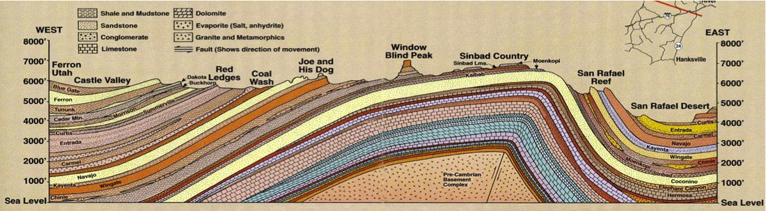
Figure 4. Cross-Section of San Rafael Swell http://www.lemkeclimbs.com/san-rafael-swell.html
Most of the rocks of the San Rafael Swell have been uplifted, crossfolded, and involved in nearly-vertical-sided collapse. Deformation in the region happened in Precambrian, Paleozoic, and Mesozoic time. Frequent deformation, uplift, intrusion, and faulting could have occurred in zones of weakness throughout this geologic time interval (Bartsch-Winkler et al. 1990). Many high-angle faults cut the sedimentary rocks. Most are normal faults, but a few reverse faults are also present. High-angle faulting probably started around the time of folding in earliest Tertiary time but reached maximum proportions later in the Tertiary. A few faults may be older than early Tertiary (Hawley et al. 1968).
Bibliography
Delaney, Paul T. and Anne E. Gartner. 1997. "Physical Processes of Shallow Mafic Dike Emplacement Near the San Rafael Swell, Utah." Geological Society of America Bulletin 109 (9): 1177-1192. http://gsabulletin.gsapubs.org/content/109/9/1177.short
Hawley, C.C., R. C. Robeck, and H. B. Dyer. 1968. "Geology, Altered Rocks And Ore Deposits of The San Rafael Swell Emery County, Utah" U.S. Department of the Interior, U.S. Geological Survey http://pubs.usgs.gov/bul/1239/report.pdf
Jeffery, D. L., J. L. Bertog, and J. R. Bishop. 2011. "Sequence Stratigraphy of Dinosaur Lake: Small Scale Fluvio-Deltaic Stratal Relationships of a Dinosaur Accumulation at the Aaron Scott Quarry, Morrison Formation, San Rafael Swell, Utah." Palaios 26 (5): 275-283. http://palaios.sepmonline.org/content/26/5/275.short
Johnson, K. M. and A. M. Johnson. 2000. "Localization of Layer-Parallel Faults in San Rafael Swell, Utah and Other Monoclinal Folds." Journal of Structural Geology 22 (10): 1455-1468. http://www.sciencedirect.com/science/article/pii/S0191814100000468
Bartsch-Winkler, Susan, Robert P. Dickerson, Harlan N. Barton, Anne E. McCafferty, V.J.S. Grauch, Hayati Koyuncu, Keenan Lee, Joseph S. Duval, Steven R. Munts, David A. Bemjamin, Terry J. Cclose, David A. Lipton, Terry R. Neumann, and Spencee Willett. 1990. "Mineral Resources of the San Rafael Swell Wilderness Study Areas, Including Muddy Creek, Crack Canyon, San Rafael Reef, Mexican Mountain, and Sids Mountain Wilderness Study Areas, Emery County, Utah." U.S. Geological Survey, U.S. Bureau of Mines http://pubs.usgs.gov/bul/1752/report.pdf
Gilluly, James. 1928. "Geology and Oil and Gas Prospects of Part of the San Rafael Swell, Utah." Contributions to Economic Geology http://pubs.usgs.gov/bul/0806c/report.pdf
Freeman, Michael L., David L. Naftz, Terry Snyder, and Greg Johnson. 2008. "Assessment of Nonpoint Source Chemical Loading Potential to Watersheds Containing Uranium Waste Dumps Associated with Uranium Exploration and Mining, San Rafael Swell, Utah." U.S. Department of the Interior, U.S. Geological Survey http://pubs.usgs.gov/sir/2008/5110/pdf/sir20085110.pdf
 RSS Feed
