The Denali Fault System, DFS, has a geological beginning dating back approximately a billion years. At this time the Earth’s tectonic plates formed a single body named Rodinia, where much of present day Alaska was submerged under water (3). Between this time period and the formation of Pangea, islands were formed from spreading centers in the Earth’s crust, and began converging towards Alaska. Around 300 million years ago these islands began to collide with the southwest coast of Alaska, bringing with it a distinct Aleutian terrane.
One key geological feature of the DFS is the Cantwell Formation, a combination of two bedding outcrops that compose much of the fault. The lower bedding outcrop is a primarily sedimentary unit, consisting of conglomerate, sandstone, siltstone, mudstone, and coal. The upper outcrop is a volcanic unit, composed of intercalated andesite, rhyolite, basalt flows, and some pyroclastic rocks. The formation of this unique segment is likely a result of thrusting from the suturing of the Wrangell and southern Alaska terrain (Ridgway, Kenneth D. et al 1997). The most recent age estimate of this formation is the Paleocene era, dating back between 56 and 66 million years ago. Age estimates were determined through the interpretation of fossil plant leaves present in the lower bedding (Ridgway, Kenneth D. et al 1997).
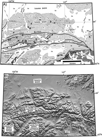 | Figure 1: A topographical view of the DFS, with the Cantwell Basin labeled. This shows the involvement of numerous tectonic plates with unique geological history, colliding over millions of years. The Cantwell Basin; however, comprises a large portion of the fault system. (1) |
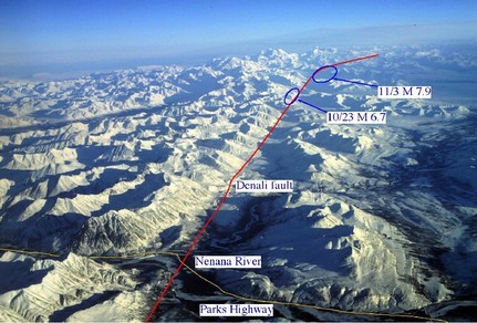
Figure 2: A high altitude perspective of the Denali Fault Systems (2). Epicenters from the 2002 earthquake series have been labeled.
After a long time period of island collision events, volcanic activity took over creating the geological system. This was around 56 million years ago, when a major subduction zone was created through the convergence of the Pacific and North American plates. This subduction contributed to the landscape through volcanic eruptions, and rising igneous minerals such as granite. Up until the present day, the Denali fault has shown moderate levels of activity, triggering a magnitude 7.9 earthquake in 2002. This event was the largest strike-slip earthquake in North America in over 150 years (Lu, Zhong. Et al 2003).
The Denali Fault System is refereed to as such because there are numerous faults present. It is convenient to view the fault as a single curve, but it is actually comprised of clusters of fault patterns. The DFS is an example of an intra-continental shear zone, with lateral extrusion as a primary feature (Jadamec, Margarete A. et al 2013). Evidence suggests that the system is a strike-slip fault, and also accommodates to large slips. Flat slab subduction has caused a mountainous region to grow above the zone, creating the highest terrain in North America. These regions primarily consist of the Aleutian slab, which was previously a collection of islands. Even now there is a large cluster of islands off the coast of Alaska, named the Aleutian Islands.
Although it is impossible to know with certainty the true nature of all system deformation, there are very accurate models which make a good illustration. Using a model which simulates the subduction between the two tectonic plates, we can have a qualitative look at system velocities. These velocities should be consistent with lateral movement along the fault.
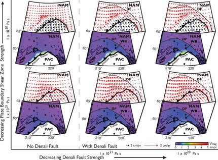
Figure 3: The figure to the left represents two dimensional cross sections of the Denali Fault System (Jadamec, Margarete A. et al 2013). With the fault in place, velocity vectors show a likelihood of slip in the direction along the fault line. This model therefore supports the strike-slip fault consensus, while being able to visually explain events such as the Denali Earthquake in 2002.
Another notable geological feature is that the fault system has essentially isolated a portion of the North American Plate. The DFS has faulted within a close proximity of the Pacific plate. This left a piece of crust surrounded by the Aleutian trench to the south, the Denali fault to the north, and the plate interface beneath. This land mass is called the Wrangell Block, and has sparked some interesting models. These unique conditions may have in fact changed Wrangell Block motion with respect to its North American plate. Some geologists hypothesize that the body is moving with the Pacific plate, while approaching the DFS (Jadamec, Margarete A. et al 2013).
This shows that geologists still have questions about the deformation properties along the Denali fault. In order to paint a better picture, models are used to simulate tectonic movement over millions of years. There are only a few number of models which can adequately describe the DFS, one being an overriding and subduction plane, combined with the underlying mantle. The modelling consists of meshes spanning 185 to 240 degrees longitude, and 45 to 72 degrees north latitude, where the DFS is. The Aleutian slab was analyzed, as it is a primary terrane of the Wrangell Block and Cantwell Basin.
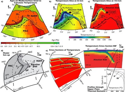 Figure 4: The images above represent two and three dimensional cuts of the Denali Fault System. Flat slab subduction is present in the cross section BB’, which is located underneath the fault system (Jadamec, Margarete A. et al 2013).
 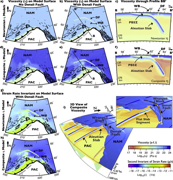 | Figure 5: The figure to the left represents the North American Plate viscosity superimposed over figure 4. (Jadamec, Margarete A. et al 2013). The model clearly illustrates the isolation of the Wrangell Block, and suggests a tendency for it to follow the pacific tectonic movements. |
The Denali Fault System is responsible for many interesting geological features, ranging from the highest altitude in North America, to the Wrangell block. The fault system has shown its slip potential in recent years, resulting in high magnitude in-land earthquakes. In terms of primary deformation, I believe these models show many characteristics of the DFS, but we are still limited in our deformation analysis.
Primary References
-Ridgway, Kenneth D., Jeffrey M. Trop, and Arthur R. Sweet. "Thrust-top basin formation along a suture zone, Cantwell basin, Alaska Range: Implications for development of the Denali fault system." Geological Society of America Bulletin 109.5 (1997): 505-523. http://www.facstaff.bucknell.edu/jtrop/Ridgway%20et%20al.,%201997,%20Cantwell.pdf
-Jadamec, Margarete A., Magali I. Billen, and Sarah M. Roeske. "Three-dimensional numerical models of flat slab subduction and the Denali fault driving deformation in south-central Alaska." Earth and Planetary Science Letters 376 (2013): 29-42. http://www.sciencedirect.com/science/article/pii/S0012821X13003257
-Lu, Zhong, Tim Wright, and Chuck Wicks. "Deformation of the 2002 Denali Fault Earthquakes, mapped by Radarsat‐1 interferometry." Eos, Transactions American Geophysical Union 84.41 (2003): 425-431. http://onlinelibrary.wiley.com/doi/10.1029/2003EO410002/pdf
Secondary References
-Bilich, Andria, John F. Cassidy, and Kristine M. Larson. "GPS seismology: Application to the 2002 Mw 7.9 Denali fault earthquake." Bulletin of the Seismological Society of America 98.2 (2008): 593-606. http://www.colorado.edu/engineering/GPS/bilich_bssa.pdf
(1) http://gsabulletin.gsapubs.org/content/114/12/1480/F4.large.jpg
(2) http://www.aeic.alaska.edu/Denali_Fault_2002/
(3) https://www.youtube.com/watch?v=waRCongzBa4
(4) https://www.youtube.com/watch?v=Npx8MK2Wyoo
 RSS Feed
