By Carla Gonzalez
Introduction
The San Andreas Fault spans 1300 km of the boundary between the North American and Pacific Plate. SAF is a right lateral strike-slip fault; it undergoes mostly horizontal motion (Richard, J. et al 2014). The fault moves approximately 30 mm per year on average. SAF is considered the principal fault, but it is divided into many different smaller faults. Because of this, the SAF is often referred to as a fault zone, which is approximately 100km wide (Richard, J. et al 2014).
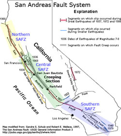 Figure #1. San Andreas Fault System divided into its Northern, Central, and Southern Segments. From http://geomaps.wr.usgs.gov/3D4Dmapping/
 The fault begins at the Mojave segment, near Bombay Beach, CA in the South. It crosses a large portion of California, passing nearby both Los Angeles and San Francisco. It finishes at the Mendocino Triple Junction, where the Pacific plate, North American plate, and Gorda plate meet. SAF is divided into Southern, Central, and Northern segments.
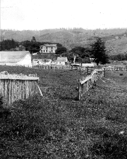 Figure #2. A fence that was broken due to the 1906 earthquake. It shows how much the fault moved in that section.
 2 major earthquakes have occurred that brought attention to this fault. The 1857 Fort Tejon (M=7.9) and the 1906 San Francisco (M=8.2) earthquakes (Richard, J. et al 2014). The 1906 earthquake led UC Berkeley professor Andrew Lawson to publish the “Lawson Report” where he declared the length of the SAF and the Franciscan Complex. The fault passes through the San Andreas Lake, after which it is named after.
Geological map
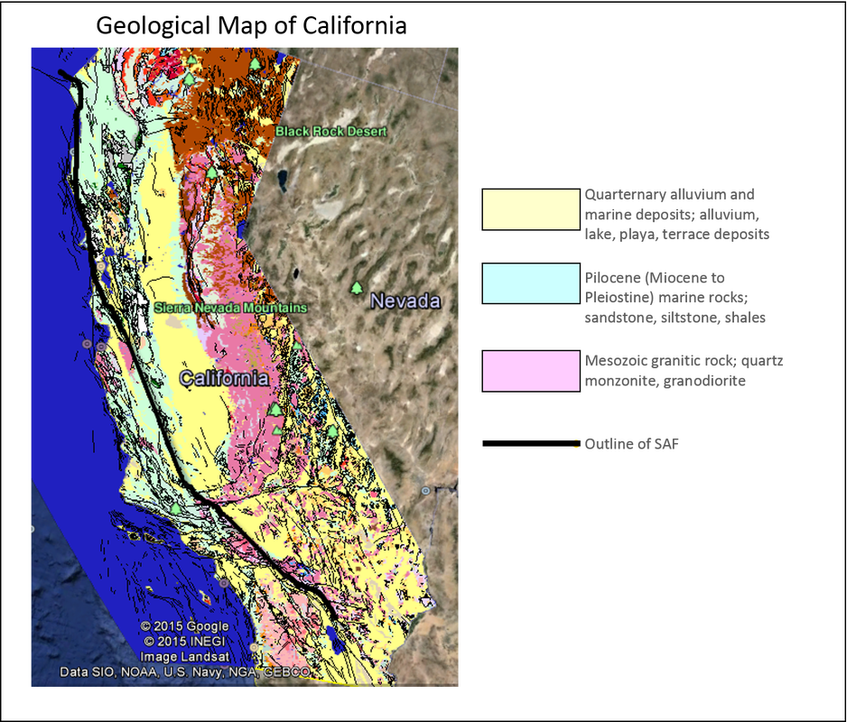
Figure #3. The legend specifies the main 3 lithologies seen along the San Andreas Fault. Picture from http://mrdata.usgs.gov/geology/state/state.php?state=CA
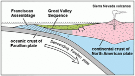 Figure #4. Shows the Farallon plate subducting under the North American plate, creating the Franciscan Complex. From http://en.wikipedia.org/wiki/Franciscan_Assemblage
 Plate tectonics and Franciscan Complex
From around 160 to 27 Mya, the Farallon plate subducted under the North American plate. That created the Franciscan Complex, in the San Francisco Peninsula, which is made of exotic accretions from this subduction. This terrain is made up of a mélange of different rock types, including basaltic rocks from the oceanic plate, ophiolites which weathered to serpentine, blueschists formed under the pressure conditions of the subduction, sandstone, and chert. Most of these rocks age back to the Mesozoic. The “remains” of Farallon plate can still be seen to the North and South of the SAF as the Juan de Fuca plate, Gorda plate,
and the Cocos plate.
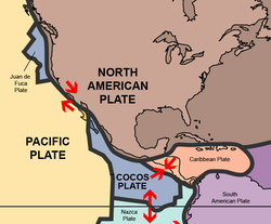 Figure #5. Shows the relative motion of the North American and Pacific plates, once the Farallon plate was subducted. From http://en.wikipedia.org/wiki/Geography_of_Mexico#
 Once subduction was complete, the Pacific and North American plates ended up against each other, with different relative motions. The Pacific plate is moving northwest, while the North American plate moves southeast. This difference in plate motion direction is the main cause for the right lateral strike-slip fault that we call the San Andreas Fault.
Carrizo plain
The Carrizo plain is a large area of grasslands in San Luis Obispo County, CA. This area is known as the Carrizo Plain National Monument and is protected due to its wildlife, archaeological and geological value. Due to its dry climate and lack of vegetation, the trace of the SAF is very clear. Rivers in this plain that cross the SAF can be used as offset markers, which can be used to calculate how much the fault moves. One such feature is the Wallace Creek, which shows a fault displacement of 9m after the Fort Tejon earthquake in 1857 (Zielke, O. et al 2010).
The Carrizo plain is a large area of grasslands in San Luis Obispo County, CA. This area is known as the Carrizo Plain National Monument and is protected due to its wildlife, archaeological and geological value. Due to its dry climate and lack of vegetation, the trace of the SAF is very clear. Rivers in this plain that cross the SAF can be used as offset markers, which can be used to calculate how much the fault moves. One such feature is the Wallace Creek, which shows a fault displacement of 9m after the Fort Tejon earthquake in 1857 (Zielke, O. et al 2010).
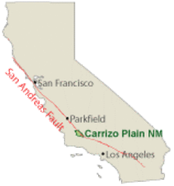 Figure #6. Shows Carrizo Plain on the California map. From: http://earthquake.usgs.gov/regional/nca/kap/ | 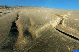 Figure #7. Shows river offset caused by fault movement in the Carrizo Plain. From http://earthquake.usgs.gov/regional/nca/kap/ |
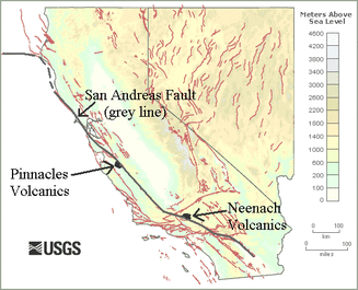 Figure #8. Shows the Neenach and Pinnacles volcanics at their respective locations due to fault movement. From http://geotripper.blogspot.ca/2009/11/volcano-sundered-field-trip-along-san.html
 Pinnacles and Neenach volcanics
During the Miocene, while the Farallon plate was subducting under the North American plate, the Neenach volcano was created. The Neenach volcano is dated to be approximately 23.5 million years old and originated near Lancaster, CA. When subduction ended, volcanic activity stopped and the volcano became extinct. The present strike-slip motion between the Pacific and North American plates began and happened to cut right through the Neenach volcano. The Western side of the volcano moved northwards and is now approximately 315 km away from its starting point. This area is now commonly known as the Pinnacles National Park. Therefore, the Neenach volcano can be an estimate of how much the total offset of the fault has been since its very beginning. Since then, the remaining rocks have undergone erosion but can still be correlated (Matthews, V. 1976).
Big Bend
The San Andreas Fault is bent for approximately 300 km in its Central to Southern segments. This interesting geological feature is due to a process called transpression. As can be seen on Fig #9, each right lateral fault has a tension and a compression stress. In this case, the compression stresses add up between the two faults, creating a restraining bend. It is in this bend that the maximum stress is perpendicular, creating compression.
The San Andreas Fault is bent for approximately 300 km in its Central to Southern segments. This interesting geological feature is due to a process called transpression. As can be seen on Fig #9, each right lateral fault has a tension and a compression stress. In this case, the compression stresses add up between the two faults, creating a restraining bend. It is in this bend that the maximum stress is perpendicular, creating compression.
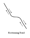 Figure #9. A restraining bend. From http://en.wikipedia.org/wiki/Transpression | 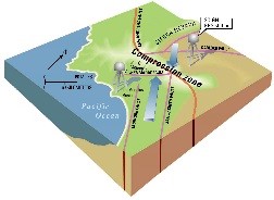 Figure #10. Shows the Big Bend and the area where compression is maximum. From http://www.earthquakecountry.info/roots/socal-faults.html |
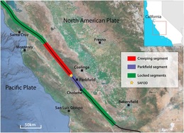 Figure #11. Shows the creeping, Parkfield, and locked segments in the Central segment of the fault. (Richard, J. et al 2014).
 Locked, creep, and Parkfield segments
The fault is divided into creep, locked, and Parkfield segments. The locked segments are those that accumulate strain over many years as the two slabs of rock slide past each other and then “unlock” producing a high magnitude earthquake. The creep segments have a constant strain rate and are aseismic in nature. These segments don’t produce large magnitude earthquakes but are in constant slip. The Parkfield segment is a transitional segment which has neither creep nor locked behavior. It has suffered several magnitude 6 earthquakes in the past decade (Richard, J. et al 2014).
The fault is divided into creep, locked, and Parkfield segments. The locked segments are those that accumulate strain over many years as the two slabs of rock slide past each other and then “unlock” producing a high magnitude earthquake. The creep segments have a constant strain rate and are aseismic in nature. These segments don’t produce large magnitude earthquakes but are in constant slip. The Parkfield segment is a transitional segment which has neither creep nor locked behavior. It has suffered several magnitude 6 earthquakes in the past decade (Richard, J. et al 2014).
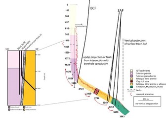 Figure #12. Shows core data taken by SAFOD. (Bradbury, K. K. 2007).
 SAFOD
SAFOD (San Andreas Fault Observatory at Depth) is a 3.2km deep borehole which is located near Parkfield, CA, approximately 1.8 km SW of the SAF (Bradbury, K. K. 2007). Drilling began in 2002 and has been divided in 3 phases of drilling and coring. The main purpose of SAFOD is to determine the composition of the SAF and help better understand and predict future earthquakes in this region. It is thanks to the information gathered by SAFOD that we have an idea about the composition of the fault core rocks in this area (Weymer, B. 2011).
SAFOD (San Andreas Fault Observatory at Depth) is a 3.2km deep borehole which is located near Parkfield, CA, approximately 1.8 km SW of the SAF (Bradbury, K. K. 2007). Drilling began in 2002 and has been divided in 3 phases of drilling and coring. The main purpose of SAFOD is to determine the composition of the SAF and help better understand and predict future earthquakes in this region. It is thanks to the information gathered by SAFOD that we have an idea about the composition of the fault core rocks in this area (Weymer, B. 2011).
References
Primary sources
Richard, J., Gratier, J. P., Doan, M. L., Boullier, A. M., and Renard, F. (2014). Rock and mineral transformations in a fault zone leading to permanent creep: Interactions between brittle and viscous mechanisms in the San Andreas Fault. Journal of Geophysical Research: Solid Earth. 119 (11). Retrieved from http://onlinelibrary.wiley.com/doi/10.1002/2014JB011489/pdf
Burnham, K. (2009). Predictive model of San Andreas fault system paleogeography, Late Cretaceous to early Miocene, derived from detailed multidisciplinary conglomerate correlations. Tectonophysics. 464 (1-4). Retrieved from http://www.sciencedirect.com/science/article/pii/S0040195107004313
Bradbury, K. K., Barton, D. C., Solum, J.G., Draper, S. D., Evans, J. P. (2007). Mineralogic and textural analyses of drill cuttings from the San Andreas Fault Observatory at Depth (SAFOD) boreholes: Initial interpretations of fault zone composition and constraints on geologic models. Geological Society of America. 3 (5). Retrieved from http://geosphere.geoscienceworld.org/content/3/5/299.full
Aalto, K. R. (2013). Examples of Franciscan Complex mélanges in the northernmost California
Coast Ranges, a retrospective. International Geology Review. 56 (5), 555-570. Retrieved from http://www.tandfonline.com/doi/pdf/10.1080/00206814.2013.879841
Weymer, B., Firth, J., Rumford, P., Chester, F., Chester, J., Lockner, D. (2011). SAFOD Phase III Core Sampling and Data Management at the Gulf Coast Repository. Scientific Drilling. 11. Retrieved from http://www.sci-dril.net/11/48/2011/sd-11-48-2011.pdf
Secondary sources
San Andreas Fault at Wallace Creek (n.d). USGS: Science for a Changing World. Retrieved March 25th 2015, from http://earthquake.usgs.gov/regional/nca/kap/
Carrizo Plain National Monument. (n.d). United States Geological Survey. Retrieved March 25th 2015, from http://3dparks.wr.usgs.gov/carrizo/index.html
Tectonic Setting. (n.d.). USGS: Science for a Changing World. Retrieved March 22nd 2015, from http://earthquake.usgs.gov/research/parkfield/geology.php
Zielke, O., Arrowsmith, J.R., Ludwig, L.G., Akciz, S.O. (2010). Slip in the 1857 and Earlier Large Earthquakes Along the Carrizo Plain, San Andreas Fault. AAAS: American Association for the Advancement of Science. 327, 1119-1122. Retrieved March 25th from, http://www.sciencemag.org/content/327/5969/1119.full
Arrowsmith, J R. (1995) The San Andreas Fault Zone in the Carrizo Plain, California: Review of Quaternary Geologic Investigations, Landforms, and Fault Activity. ASU Geology. Retrieved March 25th 2015, from http://activetectonics.asu.edu/carrizo/cargeo.html
SAFOD. (n.d.). Earth Scope. Retrieved March 22nd 2015, from http://www.earthscope.org/science/observatories/safod
Pinnacles Geology. (n.d). National Park Service. Retrieved March 25th 2015, from http://www.nps.gov/pinn/learn/nature/geology.htm
View over San Andreas fault zone to Pinnacles National Monument. (n.d). Marli Miller Photography. Retrieved March 25th 2015, from http://marlimillerphoto.com/SAF9AD2K4-014.html
Matthews, V. (1976). Correlation of Pinnacles and Neenach volcanic formations and their bearing on San Andreas Fault problems. AAPG Bulletin. 60, 2128- 2141. Retrieved from, http://archives.datapages.com/data/bulletns/1974-76/data/pg/0060/0012/2100/2128.htm#purchaseoptions
Franciscan Assemblage. (n.d.). Wikipedia. Retrieved March 22nd 2015, from http://en.wikipedia.org/wiki/Franciscan_Assemblage#
San Andreas Lake. (n.d.). Wikipedia. Retrieved March 22nd 2015, from http://en.wikipedia.org/wiki/San_Andreas_Lake
Andrew Lawson. (n.d.). Wikipedia. Retrieved March 22nd 2015, from http://en.wikipedia.org/wiki/Andrew_Lawson
San Andreas Fault. (n.d.). Wikipedia. Retrieved March 22nd 2015, from http://en.wikipedia.org/wiki/San_Andreas_Fault
Carrizo Plain. (n.d). Wikipedia. Retrieved March 25th 2015, from http://en.wikipedia.org/wiki/Carrizo_Plain
 RSS Feed
