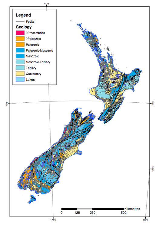
This map gives the the time period/era for most of the geology of New Zealand. (Photo from: http://sci.waikato.ac.nz/evolution/images/geology_era.pdf)
Click on the square in the bottom left corner of the map below to see satellite imagery, which shows the Alpine Fault clearly defined by the snow on the Southern Alps.
|
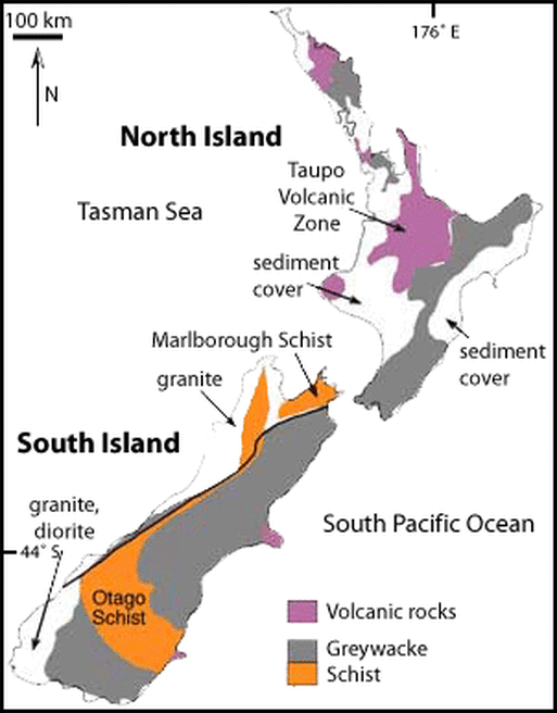
This simplified geologic map can be compared with the photo on the left to determine when each type of rock formed. Most of the rocks around the Alpine Fault are Mid-Mesozoic in age. (Photo from http://www.otago.ac.nz/ geology/features/metals)
|
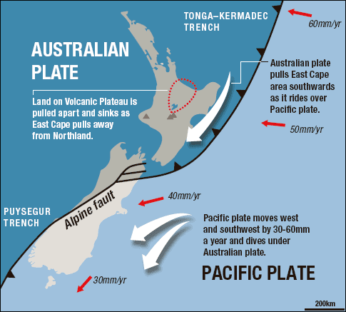
This image defines the boundary between the Australian and Pacific plates, as well as indicating the direction and rate of their motion. It also shows how near the North Island the Pacific plate is subducting beneath the Australian plate, but down south the opposite is happening. (Photo from: davies & mcsaveney, 2006)
|
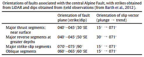
This image gives the orientation of the fault plane and slip vector for various segments of the fault. (Photo: Lund et al., 2014)
|
 http://www.geo.arizona.edu/geo5xx/geo527/SouthernAlps/geology.html
The alpine fault runs along the west side of the South Island of New Zealand and is "one of the longest, straightest, and fastest-moving plate boundary transform faults on Earth." (eg. Berryman et al., 2012). There is dextral strike-slip motion as well as convergence between the Australian and Pacific plates. The strike-slip portion of the fault is almost 900 km long and is connected to subduction zones on both ends. The fault was found to have an offset of 8000 m along a 100 km portion, with up to approximately 30 mm of right-lateral movement per year (eg. Barth et al., 2013). The convergence of the Pacific and Australian plates only began 10-15 mya and is causing uplift to occur along the fault. The rate of uplift of the Australian plate is approximately 2.6 mm per year. The orientation of various segments of the fault are given in the photo above.
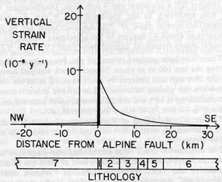
The photo to the left shows "vertical strain rates in the rocks adjacent to the Alpine Fault as a function of their distance from the fault." More uplift occurs in rocks adjacent to the fault, as shown by the increasing strain rate. (Hagbo, 2002)
The landscape consists of many formations created by glaciation and further altered by fluvial processes and landslides. Long ago expansive glaciers sculpted valleys and interrupted drainage systems causing lakes and swamps to form. Now only small glaciers remain at the peaks of mountains. Pleistocene aged glacial moraines and outwash plains were left behind during interglacial periods. Alluvial fans also spread out where rivers flow out of the mountain range. The highest river terrace is approximately 10,800 years old and has a vertical displacement of 80 m. Coastal dune ridges and discontinuous bedrock mountain ranges carved by glacial activity are the remaining major landforms of the region.
An ophiolite sequence from the Permian is offset almost 500 km and shows the minimum offset that occurred in the Neogene period. (eg. Sutherland, 1999) There is a broad mylonite zone almost 1 km thick that formed at 25-30 km of depth, now overtop of Holocene gravels. This zone was uplifted and is now exposed along the fault surface. (eg. Norris and Cooper, 2007) Pseudotachylytes are present as well as a zone of cataclasite and fault gouge almost 50 m wide along the west side of the mylonite zone. Eventually, the mylonites grade into amphibolite facies Alpine Schist.
The Alpine Fault has a much more constant earthquake recurrence interval than most faults. Over the past 8,000 years 24 earthquakes have occurred with a recurrence period of approximately 330 years. Earthquakes of about magnitude 8.0 are created when the fault slips. There is a 30% change of the next earthquake occurring within 50 years from now. (eg. Berryman et al., 2012)
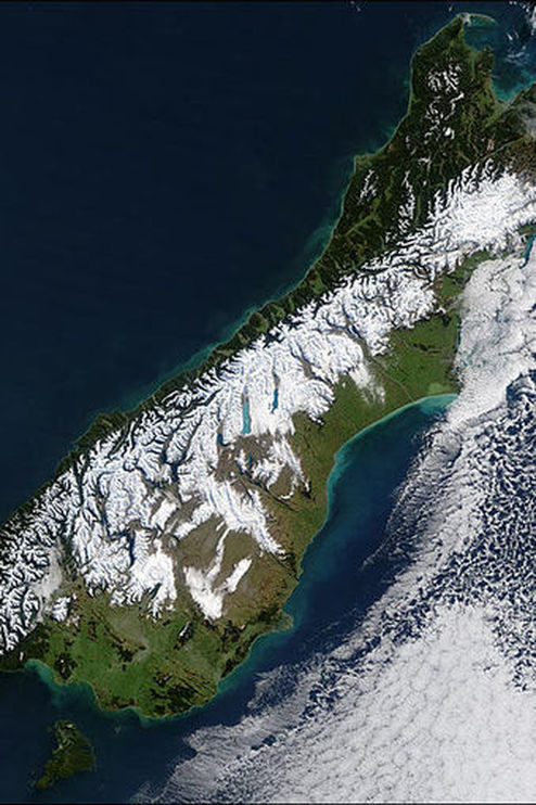
This image shows the Alpine Fault delineated by the snow-covered Southern Alps during a blizzard. (Photo from: National Aeronautics and Space Administration (NASA) Visible Earth (NASA))
Primary Sources:
Barth, N., Kulhanek, D., Beu, A., Murray-Wallace, C., Hayward, B., Mildenhall, D., & Lee, D. (n.d.). New c. 270 kyr strike-slip and uplift rates for the southern Alpine Fault and implications for the New Zealand plate boundary. Journal of Structural Geology, 64, 39-52. Retrieved September 5, 2013, from http://www.sciencedirect.com.proxy3.library.mcgill.ca/science/article/pii/S019181411300151X#
Sutherland, R. (1999). Basement geology and tectonic development of the greater New Zealand region: An interpretation from regional magnetic data. Tectonophysics, 308(3), 341-362. Retrieved March 28, 2015, from http://www.sciencedirect.com/science/article/pii/S0040195199001080
Berryman, K., Cochran, U., Clark, K., Biasi, G., Langridge, R., & Villamor, P. (2012). Major Earthquakes Occur Regularly on an Isolated Plate Boundary Fault. Science, 336(6089), 1690-1693. Retrieved March 28, 2015, from http://www.sciencemag.org.proxy3.library.mcgill.ca/content/336/6089/1690.full
Norris, R. J. and Cooper, A. F. (2007) The Alpine Fault, New Zealand: Surface Geology and Field Relationships, in A Continental Plate Boundary: Tectonics at South Island, New Zealand (eds D. Okaya, T. Stern and F. Davey), American Geophysical Union, Washington, D. C.. doi: 10.1029/175GM09
Davies, T.R.; McSaveney, M.J.; Beetham, R.D. 2006 Rapid block glides : slide-surface fragmentation in New Zealand's Waikaremoana landslide. Quarterly journal of engineering geology and hydrogeology, 39(2): 115-129
Snee, J., Toy, V., & Gessner, K. (2015). Significance of brittle deformation in the footwall of the Alpine Fault, New Zealand: Smithy Creek Fault zone. Journal of Structural Geology, 64, 79-98.
Secondary Sources:
Alpine Fault. (n.d.). Retrieved March 28, 2015, from http://www.gns.cri.nz/Home/Learning/Science-Topics/Earthquakes/Major-Faults-in-New-Zealand/Alpine-Fault
Hagbo, C. (2002, April 30). Southern Alps Orogeny, New Zealand. Retrieved March 28, 2015, from http://www.geo.arizona.edu/geo5xx/geo527/SouthernAlps/index2.html
Harold Creek - Alpine Fault mylonites and pseudotachylytes, Department of Geology, University of Otago, New Zealand. (n.d.). Retrieved March 28, 2015, from http://www.otago.ac.nz/geology/research/structural-geology/alpine-fault/harold-creek.html
Virtual field trip: Alpine Fault, Department of Geology, University of Otago, New Zealand. (n.d.). Retrieved March 28, 2015, from http://www.otago.ac.nz/geology/research/structural-geology/alpine-fault/virtual-af.html
 RSS Feed
