Preliminary information
The Baikal rift system has given birth to the deepest lake in the world, which also contains the largest volume of freshwater amongst other lakes. The rift and its corollaries are important geologically for two main reasons. Firstly, the rift is active and widens by 2 cm every year, thus providing an insight to the formation of passive margins and the opening of an ocean basin. Finally, the sediments lying at the bottom of the lake, which have an average thickness of 6-7 km, have been untouched by continental ice-sheets, and consequently offer an impressive and reliable record for determining climate change over the past 25-30 million years.
The Baikal rift system has given birth to the deepest lake in the world, which also contains the largest volume of freshwater amongst other lakes. The rift and its corollaries are important geologically for two main reasons. Firstly, the rift is active and widens by 2 cm every year, thus providing an insight to the formation of passive margins and the opening of an ocean basin. Finally, the sediments lying at the bottom of the lake, which have an average thickness of 6-7 km, have been untouched by continental ice-sheets, and consequently offer an impressive and reliable record for determining climate change over the past 25-30 million years.
General description of the feature
The Baikal Rift is located in Southeastern Siberia in Russia, and trends North-East, South-West. It consists of 15 large basins from which the lake covers the central four. The entire system is approximately 2000 km in length, with an average width of 150-300km. The development of the main depression is considered to have occurred during two stages, namely the “Pre-Rift Stage” in the Late Cretaceous-Eocene (56 million years ago), followed by the “Active rifting”-stage from the Oligocene on (34 million years ago), the latter carrying the rift-structure to its current form. The active-rifting stage has later been subdivided into the slow-rifting stage and the rapid-rifting stage, which both have a distinct kinematic organization.
The rift system consists of a series of narrow rift basins, mountain ranges and fault zones that extend along the tectonic boundary of the Siberian Craton to the North and the Amurian Craton, as well as other continental fragments, to the South 1 . Overall, the system belongs to the extensional regime as can be seen by the wide range of dip-slip faults present in the region. However, the rift also displays a strike-slip component, which will be discussed in a later paragraph.
The basement rocks in the Baikal rift zone are as old as the Proterozoic, and are comprised of ancient active and passive continental margins, with many granitic plutons. Volcanism in the Cenozoic and the subsequent opening of the Tunka Basin gave mainly alkaline and subalkaline basalts, along with some embedded tholeiitic lavas. As for the sedimentary infill, it has been divided into three main units. The deepest and oldest, the proto-rift unit, is associated with shallow-water environments and contains clays, siltstone and fine-grained sandstone. The next stratigraphic unit, the middle-rift one, is made of coarse-grained sandstones and poorly sorted conglomerates and lies on the previously described unit with a small angular unconformity. The middle-rift unit, along with the most recent and most shallow modern-rift unit (fluvial, glacial and deltaic sediments) are both associated with increased subsidence and uplift rates. The sedimentary record thus suggests important variations in the stress field. Whereas the oldest unit are indicative of strike-slip motion, the two younger strata suggest that the stress regime has shifted to transtention (extension), which also corresponds to the rapid-rift stage that was mentioned earlier 5.
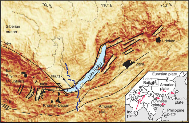
Figure 1: geological map of the Baikal rift zone
The map shows the rift basins that make up the Baikal zone, with the rift valleys whose walls dip in opposite directions. The lake itself occupies only the three central basins, namely the Northern, Middle and Southern Basins. The upper map shows, in its lower right corner, the overall movement of tectonic plates in Southern Asia. The Baikal rift is located at the junction of the stable Siberian craton and of the Amurian plate, whose motion is directed South-East. The Indian plate is also pushing in from the South, and it has therefore been proposed that the Baikal basin opens as a “pull-apart” basin caused by compression coming from the India-Asia collision.
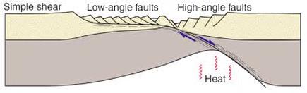 Figure 2: the Wernicke model, which is thought to explain, at least partially, the structure of the faults.
 The mechanisms that control the Baikal rift have been interpreted in two different ways 4 . The first explanation for the onset of the rifting involves active rifting, where asthenospheric material rises in the lithosphere and causes doming –the formation of elevated structures – at its surface, thus increasing tensile stress in that region. This type of rifting usually involves magmatism –as opposed to extension –, which indeed can be observed in the Baikal region, where young basaltic magmatism and locallelevated heat flow are frequent even today 2 . An alternative way to view the rifting is that of passive rifting, that in turn is caused by far-stress tectonic forces, which in this case involves the collision of the Indian plate with the Eurasian one, making the Amurian plate pulling-apart and moving to the East (see GEOLOGICAL MAP).
The rifting process is usually viewed as a mixture of both mechanisms (active and passive rifting), but because the Baikal system is so complex in terms of structure, it is thought that the dominant force driving the separation of the two adjacent plates is that of passive-rifting. In other words, the fault pattern which can be observed within the rift-region is more complex than what should be expected if only diapirism –the upwelling of hot, ductile magma into brittle overlaying rocks – was involved. It is also possible that rifting started as passive, and later became active as the lithosphere was thinned and the asthenosphere got closer to the Earth's surface.
The rifting was caused by the initial creation of small depressions, whose surfaces were tilted towards the rift axes, and who later were combined into larger and deeper depressions caused by intensified extension. The extension also caused the reactivation of pre-existing zones of weakness, since the Baikal region has been geologically active since the Proterozoic (for example the Siberian traps are located closeby). The depression consists of asymmetric half-grabens. The Northwestern region is made of a system of large steep faults, whereas the Southeastern faults are gentler and are characterised by bending and small ruptures 4 . This arrangement is thought to reflect the asymmetry of deep structures, most notably the asymmetric uplift of the crust by the mantle. Based on the geometry of the sedimentary fill of the basin, it has also been determined that the basin floor is progressively tilting, which shows that the large faults that control basin subsidence shallow out at depth 3 .
-
References
1 AGAR S.M and KLITGORD K.D, Rift flank segmentation, basin initiation and propagation: a neotectonic example from Lake Baikal, Journal of the Geological Society, October 1995, v. 152, p. 849-860
2 HUTCHINSON D.R, Depositional and tectonic framework of the rift basins of Lake Baikal from multichannel seismic data
3 LOGATCHEV N.A and ZORIN Y.A, Baikal rift zone: structure and geodynamics, Tectonophysics, 208 (1992) 273-286 Elsevier Science Publishers B.V, Amsterdam
4 MATS V.D, The structure and development of the Baikal rift depression, Earth-Science Reviews, 34 (1993) 81-118 Elsevier Science Publishers B.V, Amsterdam
5 PETIT C and DEVERCHERE J, Structure and evolution of the Baikal rift: A synthesis, Geochemistry Geophysics Geosystems, 2006, 7, pp.Q11016. <10.1029/2006GC001265>. <hal00115831
http://www.geosci.usyd.edu.au/users/prey/Teaching/Geol-3101/Rifting02/exmodel.html
http://www.geo.tufreiberg.de/studenten/Baikal_2004/baikalexcursion/geology/overview/overview.htm
http://pubs.usgs.gov/fs/baikal/
 RSS Feed
