By Kieran Tompkins
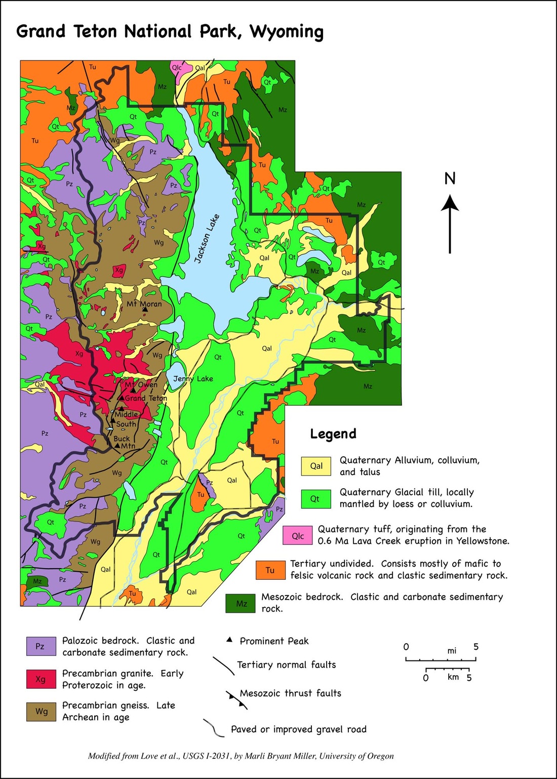
Located in North-Western Wyoming, the Teton Fault runs for approximately 65 km along the eastern front of the Teton Range (3) with visible fault scarps extending for 55 km (1). The Teton Fault is a normal fault (3), and is considered to be an active fault even though there has been no major earthquakes in recent history. The Teton Fault is responsible for the creation of the beautiful jagged mountains and along with the sprawling valley know as Jackson Hole. The highest peek in the fault zone is Grand Teton reaching an elevation of 13,770 feet and the lowest point is in the Jackson Hole Valley and it is 5,975 feet (4).
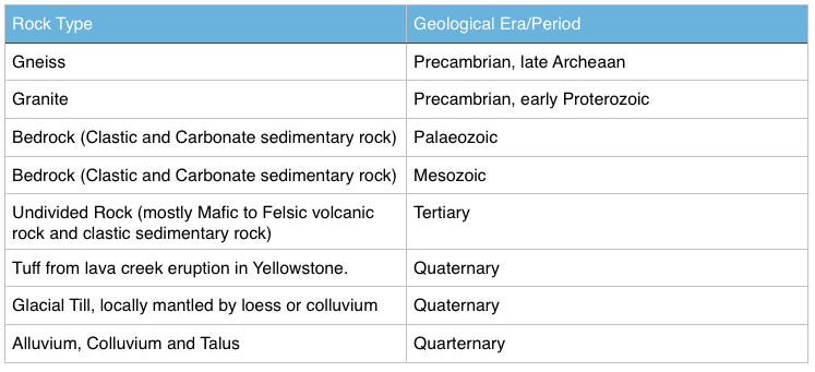
*The table below is a arranged list of the types and ages of the rocks found in the fault area taken from the geological map above.
The fault runs near the boundary of the Quaternary rocks (bright green) and the precambrian gneiss.
(http://www.marlimillerphoto.com/images/GRTEgeomap.jpg )
(http://www.marlimillerphoto.com/images/GRTEgeomap.jpg )
Age
The Teton Range is considered to be a very young mountain range if it is viewed on geological timescale and when its formation is compared to that other ranges around the world. This relative age of the mountain range is said to be the reason for the lack of foothills present and the reason for the sharp jagged shape of the mountain range. Below is a table showing the rock type and the approximate age of the rocks that make up the Teton Fault zone taken from the geological map show above.
The Teton Range is considered to be a very young mountain range if it is viewed on geological timescale and when its formation is compared to that other ranges around the world. This relative age of the mountain range is said to be the reason for the lack of foothills present and the reason for the sharp jagged shape of the mountain range. Below is a table showing the rock type and the approximate age of the rocks that make up the Teton Fault zone taken from the geological map show above.
General Description
The Teton Fault extends for 65km along the base of the Teton mountain range. It is located near a junction of four tectonic provinces (Basin and Range, Idaho-Wyoming Thrust Belt, Rocky Mountain Foreland and Snake River Plain-Yellowstone Volcanic Plateau). The Teton Fault has an average strike of 010 degrees and has a dip of 45-75 degrees in the east direction (1). The Teton Fault is credited for creating one of the most visually stunning mountain ranges in the world. Evidence of the presence of the fault can be seen by observing four major features of the Teton Range. The strait and deep east face of the range, absence of foothill, asymmetry of the range and the visible fault scarps along the eastern face of the range (2).
Deformation History
The fault underwent major compression and crustal thickening during the Mesozoic era and early Tertiary period causing the formation of thrust faults and folds (6). This was cause by the Farallon slamming into and diving under the North-American plate (6). The crustal thickening process stopped in the late Tertiary period and changed into extensional forces. The expansion occurring west of the newly formed Rocky Mountains caused the cracks in crust of the earth, one which was the Teton Fault. Nearly all the seismic activity which is responsible for the formation of this beautiful landscape occurred between 10 and 2 million years ago (1) during this extensional period. This is a highly debated topic as the age of initial displacement of the fault has not been agreed upon by experts (1). The expansion occurring caused a number of major earthquakes ranging from 7-7.5 on the richter scale (5) along the Teton Fault during this time. The combination of the stress from these massive earthquakes with the magma hotspot driving up under Yellowstone and the presence of the Teton Fault caused major movement along the fault, averaging 3 to 6 feet of vertical displacement per earthquake (Windows Into the Earth; Smith and Siegel, 2000) . The result of this movement was the west block rose upward creating the Teton Range and the east block dropped creating the valley which is know today as Jackson Hole. During the 8 million year time period during which the vast majority of the movement along the fault occurred, 25,000 to 30,000 feet of displacement occurred (2). Averaging at a rate of 1 foot every 300-400 years (2). The intense landscape of the Teton Range can be credited to the harsh glaciers that formed and preceded to melt over hundreds of thousands of years (2). These glaciers eroded the west block into the jagged mountains present today.
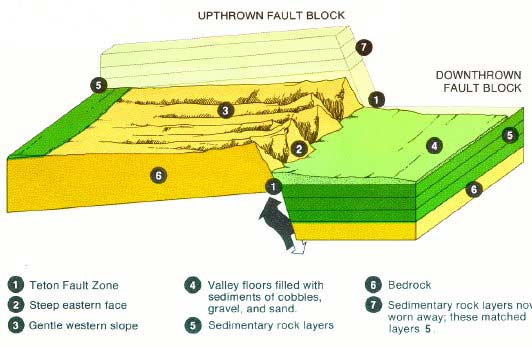
*The above image illustrates the deformation and the movement along the fault. The eastern block can be seen to have clearly moved down relative to the western block and vice versa.
(http://www.hanksville.org/daniel/geology/images/faultscarp.jpg)
(http://www.hanksville.org/daniel/geology/images/faultscarp.jpg)
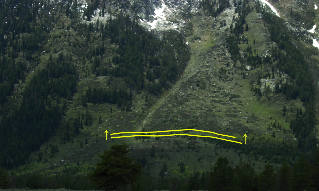
*Although the fault itself is approximately 65km long, visible fault scarps such as the one show in the photo above are visible along only 55km of the base of the mountain range. The visible scarps provide evidence of the movement which took place along the fault.
(http://all-geo.org/highlyallochthonous/wp-content/uploads/2010/09/Teton-scarp-2.jpg)
(http://all-geo.org/highlyallochthonous/wp-content/uploads/2010/09/Teton-scarp-2.jpg)
Below is a video illustrating the deformation that occur along the Teton Fault and the formation of the Teton Range in chronological order.
(https://www.youtube.com/watch?v=QfXfRbJFd0g)
References:
1. The Teton fault, Wyoming: Topographic signature, neotectonics, and mechanisms of deformation.John O. D. Byrd Robert B. Smith John W. Geissman.
http://www.uusatrg.utah.edu/PAPERS/TetonFault.JGR.pdf
2.Creation of the Teton Landscape: The Geologic Story of Grand Teton National Park.
http://www.nps.gov/parkhistory/online_books/grte/grte_geology/sec3.htm
3.WYOMING STATE GEOLOGICAL SURVEY: Teton Range
http://www.wsgs.wyo.gov/research/stratigraphy/TetonRange/Default.aspx
4.National Park Service, Grand Teton: Park Statistics
http://www.nps.gov/grte/learn/management/statistics.htm
5.http://www.tetonwyo.org/em/topics/earthquake/201705/
6.Discover Grand Teton: Geological Timeline
http://www.discovergrandteton.org/teton-geology/geologic-timeline/
1. The Teton fault, Wyoming: Topographic signature, neotectonics, and mechanisms of deformation.
http://www.uusatrg.utah.edu/PAPERS/TetonFault.JGR.pdf
2.Creation of the Teton Landscape: The Geologic Story of Grand Teton National Park.
http://www.nps.gov/parkhistory/online_books/grte/grte_geology/sec3.htm
3.WYOMING STATE GEOLOGICAL SURVEY: Teton Range
http://www.wsgs.wyo.gov/research/stratigraphy/TetonRange/Default.aspx
4.National Park Service, Grand Teton: Park Statistics
http://www.nps.gov/grte/learn/management/statistics.htm
5.http://www.tetonwyo.org/em/topics/earthquake/201705/
6.Discover Grand Teton: Geological Timeline
http://www.discovergrandteton.org/teton-geology/geologic-timeline/
 RSS Feed
