By Kassandra Sofonio
The Corinth rift is a product of extensional processes that lead to the creation of the Gulf of Corinth.
The Corinth rift is a product of extensional processes that lead to the creation of the Gulf of Corinth.
Figure 1: Embedded Google Map showing the Gulf of Corinth
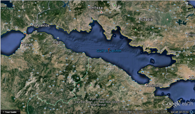
Figure 1.B: Google earth map of the Gulf of Corinth showing topography
An Overview:
The Gulf of Corinth is located between the Peloponnese (a peninsula in southern Greece) and Central Greece. It is approximately 105km long, has a maximum depth of 900m and is bounded by active normal faults. (2) On the western side, the Gulf is connected to the Mediterranean Sea and the eastern side ends with two gulfs; the Gulf of Alkionides (upper) and the Gulf of Lechaids (lower). See Figure 2 to get a clearer sense of the locations. The Corinth Rift has a strike of 100-110⁰ N (1) and is one of the most seismically active zone in Europe. (2) For example, in on June 15 1995, the Aigion Earthquake occurred with a magnitude of 6.2 (4). According to the research paper “Rifting and shallow-dipping detachments, clues from the Corinth Rift and Aegean,” the Gulf of Corinth is the fastest-spreading documented intracontinental rifts on Earth (1). Extension is geodetically measured to be 1.5cm/year and is mainly accommodated within the offshore section. According to the same paper, the rift is part of “a wider zone of extension distributed over the whole Aregean domain and has been considered the most recent event of a continuum of extension with a localization through time.” (1) It is a North-South extension and when looking at it on a larger more global scale, we can see that it is located on the European plate which is actively subducting under the African plate at a rate of 10mm per year. (2) Steep normal faults control the kinematics of extension, where one set of North dipping faults predominates giving it an asymmetrical structure. (1)
The Gulf of Corinth is located between the Peloponnese (a peninsula in southern Greece) and Central Greece. It is approximately 105km long, has a maximum depth of 900m and is bounded by active normal faults. (2) On the western side, the Gulf is connected to the Mediterranean Sea and the eastern side ends with two gulfs; the Gulf of Alkionides (upper) and the Gulf of Lechaids (lower). See Figure 2 to get a clearer sense of the locations. The Corinth Rift has a strike of 100-110⁰ N (1) and is one of the most seismically active zone in Europe. (2) For example, in on June 15 1995, the Aigion Earthquake occurred with a magnitude of 6.2 (4). According to the research paper “Rifting and shallow-dipping detachments, clues from the Corinth Rift and Aegean,” the Gulf of Corinth is the fastest-spreading documented intracontinental rifts on Earth (1). Extension is geodetically measured to be 1.5cm/year and is mainly accommodated within the offshore section. According to the same paper, the rift is part of “a wider zone of extension distributed over the whole Aregean domain and has been considered the most recent event of a continuum of extension with a localization through time.” (1) It is a North-South extension and when looking at it on a larger more global scale, we can see that it is located on the European plate which is actively subducting under the African plate at a rate of 10mm per year. (2) Steep normal faults control the kinematics of extension, where one set of North dipping faults predominates giving it an asymmetrical structure. (1)
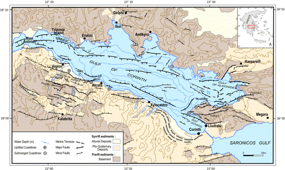
Figure 2: Geological map showing deposits, topography, faults and the uplift or submergence of coastlines (Retrieved from Corinth Rift Laboratory website)
Unlike other continental extensions (such as the East African rift system), the Corinth extension is quite young, and the first extension is thought to have started in the Pliocene Epoch (4 and 2 Ma) (2). Evidence to support this age, was found in old syn-rift volcanics, found in the eastern part of the rift, and dated to be around 3.6 to 4 Ma. (1) Other datings, these ones found in the Megara Basin, (see Figure 2, the furthermost right side of the map, consisting of Plio-Quaternary Sediments) indicate that extension was already occurring in the Pliocene and that 2Ma ago, the deepest part of the rift was formed.(1) Studies on the southern margin of syn-rift deposits (beige area in figure 2), indicate that there was an increased subsidence at 1.0-1.5Ma and that the emergence of conglomerate fans at approximately 0.7-0.6 Ma correlate with the uplift of the southern boundary. Currently the Corinth Rift is deforming due to "activity on E-W to NW-SE orientated [on the]coastal south margin and offshore faults" (3). The orientation and location of the faults produce a "complex basin structure" unlike the simple half graben that could have been expected. (3)
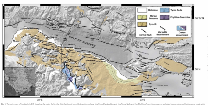
Figure 3: Geological map, showing more emphasis on the rock types (Jolivet's research paper)
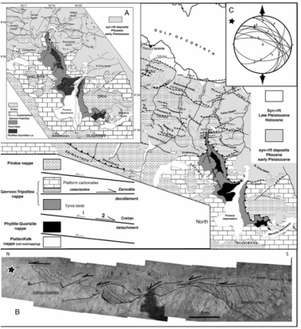 Figure 4: Magnification of Geological Map (Jolivet's research paper)
 Looking at the rock types present, there are four main layers; the PlattenKalk (PK) nappe, followed by the Phyllite-Quartzite (PQ) nappe on top, then the Gavrovo-Tripolitza (GT) nappe, and finally the Pindos nappe. The PK nappe is basically metalimestones, estimated to be from the Jurassic-Cretaceous Period (5), while the PQ nappe contains high pressure and low temperature metamorphic rocks. It has metapelites, metaconglomerates, metaquartizites, with a bit of limestone and some pieces of basement. The rocks themselves are estimated to be from the Carboniferous, Permian and Triassic Period (5). The age of metamorphism is estimated to be from the Late Oligocene to the Early Miocene. At the top of the GT nappe, there are platform carbonates including cataclasites (which is a metamorphic rock with angular clasts formed by brittle fragmentation caused by shearing (7)). At the base, however, we have Triassic pelitic (metamorphic rocks from fine-grained sedimentary protolith dated to be from the Triassic Period) and volcanogenic rocks (Tyros Beds) which are quite similar to the rocks in the PQ nappe except there is no evidence of high pressure low pressure (HP-LT) metamorphic imprint. (1) Thus we have a metamorphic gap between the two beds where a maximum pressure of 10kbar is recorded in the PQ nappe while only pressures beneath 5-6kbar were observed in the Tyros Beds. To explain this discontinuity, the Cretan detachment was proposed, which is basically a shallow-dipping detachment resulting with the exhumation of the high pressure rocks. There is a large shear zone at the top of the PQ nappe in Crete (an island below the Peloponnese). This exhumation occurred before the post-orogenic extension and was estimated to have taken place in Early and Middle Miocene. However, part of the detachment system was reactivated around Middle Miocene to early Pliocene (leading to the creation of the East Peloponnesus Detachment and the Itea-Amfissa Detachment). These detachments occurred before the Corinth Rift. In the Zaroukla-Feneos window, located beneath the Corinth Rift, (see Figure 3 where the purple PQ nappe is clearly exhumed), there is evidence that the GT nappe behaved as a shallow-dipping detachment during the formation of the Corinth Rift and it explains the discontinuity between the Tyros beds and the PQ nappe (1). This detachment was baptized as the Zaroukla detachment. Figure 4 has an excellent cross section displaying the layers and their deformation mechanisms. On top of all these layers, we have the Pindos nappe composed of sediments which is thought to have been an oceanic basin that rifted during the Triassic Period. It is believed that it received its maximum width in the Jurassic-Cretaceous time period.
Analyzing the Geological Maps:
Looking at figure 2, we can see that there are numerous major normal faults dipping towards the north on the land of the southern border of the Gulf. Some faults that are shown on Figure 2 include the southern faults Helike, Xylocastro, Doumena etc. Faults between Aigion and Akrata have a strike varying between 070°N and 120°N and a dip between 70° and 45°, averaging around 60°-55° (2). The faults along the southern coast are en echelon, meaning they are closely spaced, approximately parallel and overlapping. (3) Evidence from seismological studies support the view that these faults are planar surfaces that continue to depth. The other model proposed consists of regional listric faults and a low angle detachment system (2). On the southern edge we also see many synrift sediments (which is basically sediments deposited at the same time as the rifting) of Pllo-Quaternary deposits. According to the Corinth Rift Laboratory, there is increase of thickness in the synrift deposits from south of Akrata to Xylocastro. (2) When observing the northern border, it is interesting to note that the faults are not actually on the shore. These faults are dipping towards the south and are located in the actual Gulf. In addition, there is no synrift deposits. These two factors have led to the acceptance of an asymmetric model, as mentioned previously in the overview.
On the southern border we also have an uplift of coastlines, while on the eastern side, near the Gulf of Alkionides, we have a bit of submerging coastlines. The southern coast is uplifting at a rate of 1 to 1.2mm/year (2). The mechanisms used to explain this uplifting include lateral flow of the lower crust or the elastic rebound of the footwalls (2). Reasonably, there are also alluvial deposits around the water edge (most apparent near the Gulf of Lechanios above the marine terraces).
When comparing this map which Figure 3, we can see that the alluvial deposits correspond with the white Holocene deposits (deposits from the Holocene epoch). In this geological map, however, we can also see the exhumation of Tyros Beds and the Phyllites-Quartzites. The Zaroukla detachment and the Cretan detachment, mentioned previously, are also clearly illustrated.
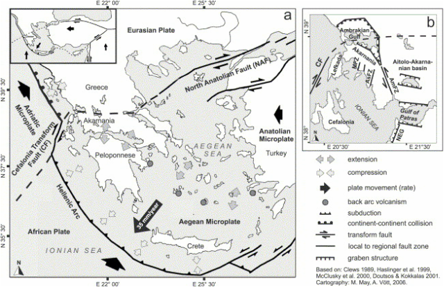
Figure 5: Tectonics Surrounding the Corinth rift (Corinth Rift Laboratory Website)
Tectonics- External Stress:
The present day tectonics involved in the Corinth Rift are quite influential. As mentioned previously, the African plate is actively colliding and subducting below the European plate. (2) Starting from approximately 5 Ma to present day, plate kinematics have been mostly “compatible with the westward extrusion of Anatolia (see Figure 5) along the NAF (North Anatolian Fault) which ends in the transtensional North Argean trough” (1). This extrusion is caused by the collision of the Arabian plate into the Eurasion plate (at a rate of 20-25 mm per year) and is accommodated by the NAF which was initiated 10 to 13 Ma as a dextral plate boundary. Displacement along the NAF is calculated to be 23 to 33 mm/year. The Aegean Region, part of Turkey, (see Figure 6) is a rigid block moving toward the Hellenic trench at a rate of 35mm/year (with respect to Europe). Just like the Anatolian, the movement of the Aegean Region is also accommodated by the NAF. At around 6 to 4 Ma, the NAF, moving southwest, reached the Aegean sea. NAF bifurcates into two branches where the northern branch can be traced to the Corinth Rift. (2)
The present day tectonics involved in the Corinth Rift are quite influential. As mentioned previously, the African plate is actively colliding and subducting below the European plate. (2) Starting from approximately 5 Ma to present day, plate kinematics have been mostly “compatible with the westward extrusion of Anatolia (see Figure 5) along the NAF (North Anatolian Fault) which ends in the transtensional North Argean trough” (1). This extrusion is caused by the collision of the Arabian plate into the Eurasion plate (at a rate of 20-25 mm per year) and is accommodated by the NAF which was initiated 10 to 13 Ma as a dextral plate boundary. Displacement along the NAF is calculated to be 23 to 33 mm/year. The Aegean Region, part of Turkey, (see Figure 6) is a rigid block moving toward the Hellenic trench at a rate of 35mm/year (with respect to Europe). Just like the Anatolian, the movement of the Aegean Region is also accommodated by the NAF. At around 6 to 4 Ma, the NAF, moving southwest, reached the Aegean sea. NAF bifurcates into two branches where the northern branch can be traced to the Corinth Rift. (2)
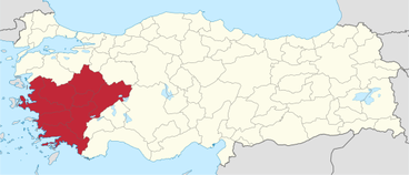
Figure 6: Aegean Region in Turkey (Retrieved from http://upload.wikimedia.org/wikipedia/commons/thumb/d/d6/Aegean_Region_in_Turkey.svg/2000px-Aegean_Region_in_Turkey.svg.png)
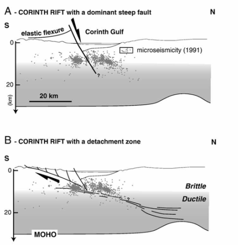 Figure 7: The two models proposed for the Corinth rift (Jolivet's research paper)
 Deformation History:
The Corinth Rift is thought to undergo extension by a combination of: westward propagation of the North Anatolian fault (NAF), back-arc extension due to the subduction of the African plate at the Hellenic Trench (see figure 5, the Hellenic Arc), and gravitational collapse of the lithosphere (3). According to the theory of the involving the NAF , the purpose of the Corinth Rift is to accommodate the “strike-slip motion by extension and rotation of the fault system”. (2)
As mentioned previously in the geological map analysis, there is a slight divergence in ideas concerning the structures involved in the Corinth rift. Some people believe that it is composed of a dominant steep fault while others think it has a detachment zone. In the southern margin, there are steep active normal faults. Normal faults generally don’t go further than 10-15 km deep, and further than that, we have a shallow-dipping shear zone in the middle and lower crust. Other models show that the steeply dipping normal fault in the upper crust continues at depth by a ductile flow in the lower crust. There is no detachment required in this model. The other model involves a deep, low angle North dipping detachment zone (3). According to Jolivet’s research paper, low angle normal faults are detachments and can cut across a nappe stack. In addition, the juxtaposition of a superficial unit on top of a deep metamorphic unit results from motion along a detachment. However, as it is mentioned in Bell's paper, this model is not compatible with factors such as the offshore basin stratigraphy, These two ideas are clearly summarized and illustrated in Figure 7.
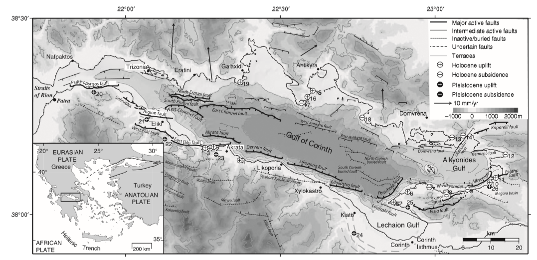 Figure 8: Illustration of individual faults, including uplift and subsidence according to their time frame (Bell's Research paper)
 By analyzing the sediments, Bell was able to construct a timeline for the evolution of the Corinth Rift which is summarized below:
Past till approximately 2 Ma
There was a wide western rift with activity along numerous faults (3) and it underwent little subsidence (we know this because there is no evidence of deposition).In the easternmost part of the system, extension was focused onshore at the NW-SE trending Megara basin (south of the present day Gulf of Alkionides, see figure 2 for a clearer visualization) (3)
Approximately 1-2 Ma to 0.4 Ma
The extension in the Megara basin ceased at about 0.8-2.2 Ma when activity transmitted to the Gulf of Alkionides to the north (3). Three individual depocenters (the location of the thickest deposition in a basin) are formed. The western depocenter is controlled by a South dipping fault system while the eastern depocenter is controlled by North dipping fault system. (3). Both North and South dipping faults are significant in this time period.
Approximately 0.4 Ma to recent
The depocenters are now linked. A single 80 km depocenter is formed and is controlled by the North dipping faults on the southern edge.
Faults Derveni and Likoporia (see Figure 8) experienced an important increase in displacement. In addition, the slip rates of Derveni and Likoporia (located in the central part of the rift) were greater than those of Eliki and Xylokastro (faults located in the western and eastern part of the rift respectively)
North dipping faults dominate basin subsidence (this generalization excludes the westernmost basin).
Recent Activity is interpreted by seismicity and geodetic rates. Currently, "microseismicity is concentrated in the Aigon and Rion graben regions" (see western part of the Gulf in Figure 8) (3)
Bell provides an excellent model summarizing the rift evolution which includes the following steps:
1. rifting initiates in isolated depocenters
2. the major faults controlling the initially isolated basins dip both north and south (however the more the rift evolves, the north dipping faults become more dominant, as it is currently observed in present day)
3. faulting migrates northward
Thus the Corinth Rift had a rather complex evolutionary history, including migration of fault activity, the linkage of depocenters and the tendency of dominating North dipping faults on the southern coast. It is these processes that lead to the creation of the beautiful (present day) Gulf of Corinth, located in Greece.
References:
Primary Sources:
(1) Jolivet L., Labrousse L., Agard P. et al., Rifting and shallow-dipping detachments, clues from the Corinth Rift and the Aegean, Tectonophysics, 287-304, 2010
http://ardoise.ens.fr/IMG/pdf/Jolivet_et_al_Tectonophysics_2010.pdf
(2) General Tectonic Context of the Corinth Rift (2009, May) Retrieved from http://crlab.eu/
(3) Bell R., L. McNeill, J. Bull, T. Henstock, R. Collier and R. Leeder, Fault Architecture, basin structure and evolution of the Gulf of Corinth Rift, central Greece, Basin Research, 2009
http://ardoise.ens.fr/IMG/pdf/Bell_basin_research2009.pdf
Secondary Sources:
(4) The rift of Corinth. Retrieved from http://www.ipgp.jussieu.fr/~bernard/GAIA/resume-corinth.html
(5) Robertson, A. (2006). Tectonic development of the Eastern Mediterranean region. London: Geological Society.
https://books.google.ca/books?id=R3m1XNShu7IC&pg=PA134&lpg=PA134&dq=age+of+the+pq+nappe&source=bl&ots=uz3W8JIvzf&sig=gHPcaABI77oGTKRPoNycRFK-iSU&hl=en&sa=X&ei=DM8NVa_-E8qWgwTQ4YLYDg&ved=0CCsQ6AEwAg#v=onepage&q&f=false
(6) National Oceanography Centre, Southampton (UK). (2009, December 23). Formation of the Gulf of Corinth rift, Greece. ScienceDaily. Retrieved from www.sciencedaily.com/releases/2009/12/091222105215.htm
(7) Imperial College Rock Library. Retrieved from https://wwwf.imperial.ac.uk/earthscienceandengineering/rocklibrary/viewglossrecord.php?Term=cataclasite
 RSS Feed
