THe Himalayan Frontal Thrust by thomas St-Laurent
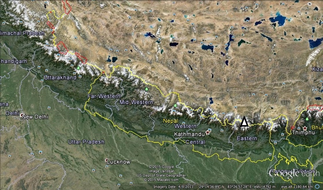
Figure 1. Himalayas
The Himalayan mountain range is one of the biggest mountain ranges of the world. It spans 2900 km across Nepal and India. Notably, Mount Everest (shown by a white triangle), with a peak above 9 km in altitude, the highest point on the Earth, is in the Himalayan mountain Range.
The Himalayan Frontal Thrust, also known as Himalayan Frontal Fault, is the youngest and most active fault of the Himalayas. The three main Himalayan faults are the Himalayan frontal thrust, the Main Boundary Thrust and the Main Central Thrust (not shown).
The Himalayan Frontal Thrust, also known as Himalayan Frontal Fault, is the youngest and most active fault of the Himalayas. The three main Himalayan faults are the Himalayan frontal thrust, the Main Boundary Thrust and the Main Central Thrust (not shown).
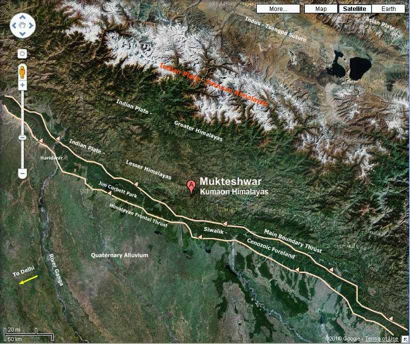
Figure 2. Himalayan Frontal Thrust and Main Bounday Thrust ( 6 )
This immense mountain range has a long history. To understand how it came to be, we have to travel back to Pangea, the supercontinent.
About 225 Ma, the landmass that we know today as India was still attached to what is today known as Africa. Over the next 25 million years, the Indian tectonic plate slowly broke off of Africa and headed north to Asia. Fast forward to 80 Ma; the Indian land mass, moving at a speed varying from 15 to 20 cm/yr, is nearly six and a half thousand kilometer away from the Eurasian tectonic plate. Over the next 70 million years, the Indian plate finished its voyage across the ocean and 10 Ma, collided with the Eurasian plate.
About 225 Ma, the landmass that we know today as India was still attached to what is today known as Africa. Over the next 25 million years, the Indian tectonic plate slowly broke off of Africa and headed north to Asia. Fast forward to 80 Ma; the Indian land mass, moving at a speed varying from 15 to 20 cm/yr, is nearly six and a half thousand kilometer away from the Eurasian tectonic plate. Over the next 70 million years, the Indian plate finished its voyage across the ocean and 10 Ma, collided with the Eurasian plate.
|
Once the two tectonic plates collided this caused enormous stress on the two plates. “Neither continental plate could be subducted due to their low density/buoyancy. This caused the continental crust to thicken due to folding and faulting by compressional forces.” (1) In this way we can understand that there was crustal shortening in the north-south direction. With all that landmass under stress from all directions, the landmass went in the only possible direction to relieve the stress, skyward, at a rate of “1 cm per year” (2). This process is still happening, the two plates are still being pushed into each other. However, erosion from the melting of icecaps dampens the growth of the mountains.
|
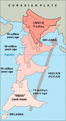
Figure 3. Indian-Eurasian Collision (1)
|
For a more in depth animation of the formation of the Himalayan Mountains, consult: http://www.geolsoc.org.uk/Plate-Tectonics/Chap3-Plate-Margins/Convergent/Continental-Collision
The initial collision of the two tectonic plates occurred while there was still a sea separating the Asian and Indian land masses. Once these two tectonic plates collided, the velocity of the Indian plate decreased significantly to 5 cm/yr. As the two land masses approached each other, the sea floor sediments were compressed and brought to the surface with the thickening of the crust. The two land masses officially collided when the sea was completely drained. Since the initial collision, several enormous earthquakes occurred to relieve this stress. The main central thrust was formed upon this initial collision and over the next few million years the main boundary thrust was created. “The initiation age of the [Himalayan Frontal Thrust] is constrained between 500 and 100 Ka.” (3) The Himalayan Frontal Thrust is the youngest and thus the most active out of the Himalayan Thrusts. “The [Main Central Thrust] is mainly inactive […] and the [Main Boundary Fault] in localized areas exhibits neotectonic acticity.” (3)
We know The Himalayan Frontal Thrust itself is a NW-SE trending thrust fault where the hanging wall is pushed up the footwall. The Frontal Thrust is the boundary between the Sub-Himalaya, often called Siwalik layer, and the north Indian plains. “A slip rate of ≥ 13.8 ± 3.6 mm/yr on the [Himalayan Frontal Thrust] has been estimated on the basis of a radiocarbon date, […] assuming an average fault dip of NE 30°” (3). This is thrusting the Siwalik layer above and onto the Ganges plains. The Siwalik layer is made up of Cenozoic sediments and consists mostly of animal fossils, elephants and horses, to name a few, that made up the wildlife at the time. The northern plains consists of the youngest sediments and the youngest layer of the Himalayan region.
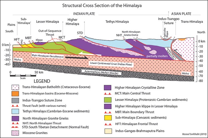
Figure 4. Geological Cross section of Himalayan region (4)
The Himalayan Frontal thrust was originally thought to be a blind fault. An apparent anticline could be seen following a certain line, with shortening in a direction perpendicular to said line. An age disconformity could also be seen, with the older layer on top. With these indications, geologists explained the deformation by a blind thrust. However, recently, researchers from the Center of Neotectonic Studies of the University of Nevada, the Department of Geological Sciences of San Diego State University and the Wadia Institute of Himalayan Geology of Dehra Dun have shown evidence for traces of the exposed Himalayan Frontal Thrust. These researchers have found that at many sites along the Himalayan Frontal Thrust, namely, Rampur Ganda, Lal Dhang and Ramnagar, “trench exposures and vertical separations of 9-13 m are interpreted to indicate about 13 – 26 m of coseismic slip during the last earthquake.” (5) By analyzing these locations, these geologists have been able to date the simultaneous fracture to 1413 ± 9 A.D5. This indicates that a powerful earthquake caused more slip along the fault at this date. A few earthquakes have occurred in the last century, “the 1905 Kangra earthquake, 1934 Bihar-Nepal earthquake, and 1950 Assam earthquake.” (5) However, little is recorded of the surface rupture that happened during these earthquakes. The aforementioned geologists believe “that the earthquake recorded in the trenches is larger than historical earthquakes and indicate a potential for sections of the [Himalayan Frontal Thrust to rupture simultaneously along lengths of the [Himalayan Frontal Thrust]” (5)
This is quite an important observation since the fault is still active, geologists and geophysicists will be better suited to study the Himalayan Frontal Thrust. They will then be able to make predictions about potential seismic activity in the area. Similarly, with a better understanding of the geology of the fault scientists, could make better estimations of what the Himalayas will look like in the near and distant future.
This is quite an important observation since the fault is still active, geologists and geophysicists will be better suited to study the Himalayan Frontal Thrust. They will then be able to make predictions about potential seismic activity in the area. Similarly, with a better understanding of the geology of the fault scientists, could make better estimations of what the Himalayas will look like in the near and distant future.
Works Cited
http://pubs.usgs.gov/gip/dynamic/himalaya.html (2)
http://www.geolsoc.org.uk/Plate-Tectonics/Chap3-Plate-Margins/Convergent/Continental-Collision (1)
http://www.iisc.ernet.in/currsci/jun102004/1554.pdf (3)
https://www.himalayanclub.org/hj/66/9/geologic-formation-of-the-himalaya/ (4)
http://cires1.colorado.edu/~bilham/HimalayanEarthquakes/Himalayan_thrust.pdf (5)
http://suvratk.blogspot.ca/2010/10/going-hiking-in-lesser-himalayas.html (6)
 RSS Feed
